 Cambridge History - a personal viewCambridge History - a personal view
All photos by me. More at my flickr photostream, please visit !
Nota Bene These pages are not being maintained at the moment. There are two main reasons for this: I used to have an
office in the city centre right next to the Central Library, which houses the Local History Collection. I could nip into it
at lunchtime to do a bit of reading. I no longer work in the town centre and a trip in is a 15 minute cycle. More importantly
the Central Library has been closed for rebuilding for several years now, and the Local History Collection has been
inaccessable. In these circumstances I have had to give up (for now). I am still happy to get emails about these pages
but I cannot answer questions - I don't have the time or the sources, sorry.
This is good: aerial view of Cambridge with places of interest tagged.
Someone suggested I get a link from the Tourist Office. I don't want to do that as a) I'd have
to start being truthful,accurate and responsible, and b) I'd have to stop being rude about
tourists. However, I can put a link in to them:
The Tourist Info centre
and while I'm at it here are a few other Cambridge related links:
Addenbrooke's Hospital
ADC
All Saint's Passage
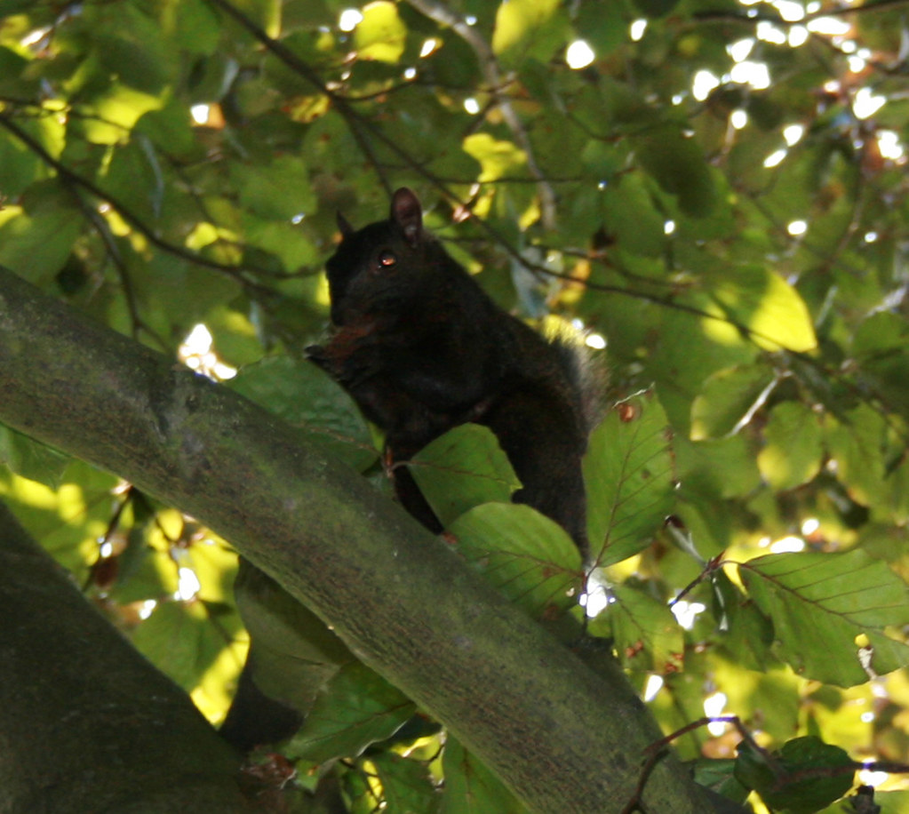
Barnwell The first time I saw one of these I thought
I was hallucinating. They are a "melanistic phase" of the ordinary Grey Squirrel, i.e. not a distinct
species, melanism being the opposite of albinism. They're relatively rare in Europe, but do crop up in
various bits of East Anglia, and in particular in North Cambridge. I see one hopping about in my back
garden fairly frequently. If you manage to get really close you can see that they're actually very dark
brown, just like a black cat. The photo was taken by the Astronomy Dept on Madingley Road.
The Botanical Garden
Bradwell's Court
Bridges and Ferries
Bridge Street and Portugal Place
Cambridge Blue and
Porterhouse Blue
Cambridge Fields
CUFC This is, surprisingly
enough, a real hill. The Roman town of Durolipons (or possibly
Durcinate, or Curcinate, or Durovigutum, or Camboritum, nobody seems
too sure) was here, extending roughly from the river up to the Mount
Pleasant Junction. There was a Castle on the Castle Mound site in Roman
times, probably wooden. The Normans built a stone castle, and this was
later extended and improved, particularly by Cromwell. From soon
afterwards, however, the only part standing was the gatehouse. The
first stone of the county gaol came from the old Castle, and the present
Shire Hall was built using bricks from the gaol. Admirable recycling.
The major use of the Castle was always as a prison, it was not much use
as a defensive structure (apart from a brief period during the Civil
War) as the town seems to have been invaded by pretty much anybody
passing by ("It's a nice day, let's go and invade Cambridge !"). The
gatehouse of the Castle was demolished in 1842 to make way for the
Assize Courts, which were themselves demolished in 1953 - both
demolitions subject to howls of protest, ignored as they always
are. There is a good view from the top of Castle Mound, the site of the
old Castle Keep. On the townward slope of the hill is the tiny old
St.Peter's Church, the smallest church in the county, built on the site
of a Roman temple. There is also the (most excellent) Kettles Yard
Museum and Kettles Yard House, and the very interesting Folk Museum. The area
immediately north of Northumberland Street, Castle End, was for many
centuries the major red light district of the town. The Three Tuns Inn
(also known as Whyman's Inn) on Castle Hill was a favourite haunt of
Dick Turpin, the notorious highwayman. It was demolished in 1936.
Chariots of Fire
Christ's Pieces
Cromwell's Head
Cinemas
Coe Fen, Lammas
Land, Sheep's Green, Laundress Green
Coldham's Common
Colleges
Cripps
Cycling
De Freville Estate
Development and
Redevelopment Moving up in scale
Cambridge still has largely the same pattern of roads as the medieval
city, the major difference being the loss of Milne Street which was
covered over by an earlier major redevelopment project - King's
College. Milne Street ran parallel to King's Parade but nearer the river. The two
ends are left as Queens' Lane and Trinity Lane, and the middle section
ran under the back of the Chapel. Milne Street provided access to the
riverside docks, or "hithes", which were in the area now covered by the King's and
Clare College gardens.
Moving up in scale again, the City now has a
Green Belt, a post-war invention designed to halt endless suburbian
expansion and to give the City what you might think of as "breathing
room". As in other places where this has been tried there are several
consequences: so called brownfield sites, disused industrial
areas within the green belt, become attractive development sites, and
this is going on at the Riverside gas works, sewage works and Railway
sidings sites in Barnwell. Secondly there is pressure for housing development to
"jump" the green belt, and this has happened at Cambourne and Bar
Hill. There are plans for more new villages of this sort south of
Addenbrokes and between Cambridge and Ely on various disused
airfields. One problem with this is that public transport does not keep
up, so there will be an increase in traffic on arterial roads, but there
is no room in the city for parking, so where do we put Park and Ride
schemes - in the green belt ! This is a third consequence, there is an
irresistable temptation to nibble away at the green belt. The
University is a major offender here. The West Cambridge site would be
the largest building site in Europe if all the planned buildings were to be built at
once. The University has further plans in the mostly still rural area
between Madingley Road and Huntingdon Road. In 2004 this hit the national
newspapers with headlines like "University plans 3 new colleges" to be built in
this area. As usual with newspaper reports concerning the University this is
complete rubbish. The Cambridge housing stock
is ageing and ridiculously expensive, and much of what there is is used
as student or graduate lodgings. There is a need for low cost housing
for those who provide our vital infrastructure but who are not
enormously well paid (which includes a lot of University staff, as well
as bus drivers and shop workers etc). Any houses built within reach of
the centre will probably be bought up by the wealthy young employees of the high tech
industries, so everyone else will continue to be forced out to the
villages beyond the green belt unless more of the green belt is built
on (and for all of the weasel words about sensitive development and
respecting the landscape this is fundamentally what is meant). The
employees of the high tech companies need somewhere to live if the
high tech companies are to stay here, so there is a choice: preserve the
green belt and stiffle the city, or build on it and surround the city with
boring little brick boxes out to Ely and beyond. A choice I'm glad I
don't have to make.
Dons
Driving
Fitzbillies
Fitzwilliam Museum
Fulbourn
Foreign Language
Students
The Fosters and The Turk's Head The rather
attractive Tudor shop on Trinity Street now occupied by a clothes shop was
once the Turk's Head Coffee House, one of the earliest coffee houses in
the country (17th century). It was much frequented by students. The
upper floors later became the Turk's Head Carvery, but it is now
entirely given over to floral prints. The building was
once the home of Fosters' Bank, which later moved to the truly splendid
building on Sidney Street opposite Petty Cury. The name can still be seen
carved over the door, but it was taken over by Lloyds shortly after the move.
The older part of the Sidney Street building was designed by Alfred
Waterhouse - it looks nice enough from the outside, but it's the tiled
interior that is really special, go and look ! The bank was apparently founded by
the Foster brothers, Richard and Ebenezer, for the benefit of the workers
at their mills, of which there were three in Cambridge, including the large
one still known as the Foster Mills next to the Railway Station. This has
been through several hands but is now owned by Rank Hovis. Ebenezer's
house was Anstey Hall in Trumpington, the grounds of which have now been
despoiled by the large new Waitrose supermarket.
Garden House Hotel
The Guildhall
Gog Magogs
Grafton Centre
Grantchester
Great St. Mary's and Little St Mary's
Health
Hills, Pieces, Rows and
Leys
Hobbs Pavilion
Hobson
Hobson's Conduit
The Holiday Inn
Homelessness
At the back of
Marks and Spencers Market Square branch is a small graveyard belonging to the
adjacent Holy Trinity Church. Several
of the stones belong to a family called the Hunnybuns, dating back to
the 1700's. There are no Hunnybuns left in Cambridge now, at least
according to the phone book. Shame. One of them ran the famous Coaching
House called The Hoop, roughly where the tile shop
on Bridge Street is now. There was also a Hunnybun's carriage repair
shop on Hobson Street.
An Interesting Demographic Detail
The Kite
The King's Ditch
King's Parade and Trinity Street
King Street
Lensfield Road
Lion Yard
One-way system
Major Employers
Market Passage and Rose Crescent
Market Square
Midsummer Common
Mill Road
Mitcham's Corner
Modern Buildings
Mortlock
Newmarket Road
Nightclimbing
Parker's Piece
Peas Hill
Petty Cury
Pitt Building
Pitt Club
Punting
The Railway Station
Reality Checkpoint
River Cam
St.Edmunds Passage Although the University
has always had more than its fair share of famous men of letters it is
probably best known today for its scientists. From Newton, through
Darwin, Rutherford, Crick and Watson, and many more, to Hawking
today. Prof. Hawking can occasionally be seen trundling around the town
- a friend reports seeing him once going
down King's Parade at some
speed - backwards. Apparently he had a new wheelchair and was having
problems with the controls. Tourists commonly have the apple tree
outside Trinity pointed out as Newton's famous apple tree. It's nothing
like old enough to be the apple tree (which is actually at Woolsthorpe
Manor, Lincs), but is on the site of the
small walled garden the college gave him for his private use. He bought
both his first book on astrology (yes, astrology, not astronomy) and his
famous prism at Sturbridge Fair (See the
excellent and lengthy Quicksilver by Neil Stephenson for a fictionalised account of
this event). Issac
Newton was, among other things, the
inventor of the cat flap. Darwin lived in various places around
the city, today marked by plaques, including on the site that is now Boots on
Sidney Street, and on Fitzwilliam Street. Several of the specimens he
collected are in the Geology Museum on the Downing Site. (The Darwin
descendants became prominent citizens with at one time 3 Professor
Darwins, one of whom lived in Newnham Lodge, which now constitutes a large part of Darwin
College. The local authors Gwen Raverat and Frances Cornford were both
originally Darwins). The old Cavendish Laboratory on Free School Lane was the
site of many revolutionary experiments in nuclear physics, under the
benign dictatorship of Ernest Rutherford. Rumour has it that one room is
still sealed off because of the high level of residual radiation. The
Russian physicist Piotr Kapitza used to call Rutherford the
Crocodile, and there is a crocodile carved (by Eric Gill) into the
wall of the Mond Building (New Museums Site) in which Kapitza worked.
An alternative but less interesting explanation is that the crocodile is
a common symbol in Russia for the unknown, which is why Kapitza chose it. Crick
and Watson discovered the structure of DNA while working in the Medical
Research Centre shed in the centre of the New Museums Site. For a long
period this was used as a cycle shed, but has now been renovated and is
in use by the Materials Science Department. I have seen one guide book
point out the Eagle Inn on Bene't Street as the site of the discovery,
but in fact this is where Francis Crick made a public announcement of
their discovery to the presumably rather bemused patrons. His house on
Portugal Place was until recently marked with a golden helix.
Spies
The Spinning House
Stourbridge Common
Strawberry Fair
Tourists
Trams
Tudor
Gruesomeness
Unkindness to Animals
Yard Butter This apparently died a natural death, having swum up
onto the beach at Pevensey in Sussex in November 1865 and dried out for
no well explained reason. So no Greenpeace boycotts, ok ? It is a Finback
whale, almost 70ft long, and would have weighed about 80 tonnes when alive.
The carcass was viewed by vast crowds at Hastings cricket ground for some
time before the smell persuaded the entrepreneur responsible to sell it
to the University, the money being raised by a public subscription. The
skeleton now hangs from an overhang of the brutalist Arup Building in the
New Museums Site, above the Zoology Museum. It's a nicely surreal touch,
and just about makes the otherwise hideous building worthwhile. It was
hidden from view for about 10 years by hoardings, but is now exposed to
the elements, and more destructively perhaps, the pigeons - which crap on
absolutely everything they can sit on in this Site (a valid aesthetic
comment if you ask me). Because of the pigeons it needs to be cleaned
periodically with special skeleton cleaning brushes (this is true !).
It was planned at one time to surround it with a glass case, but the
huge cost may prevent that from ever happening.
More to come...
Street Name Changes
Approaching Cambridge from London on the train, you will see on the
right a large chimney, visible day and night. This is the landmark which
signals to all the locals that it is time to put the book away and don
the coat because you will be in Cambridge Station within a few
minutes. The chimney is at the centre of Addenbrooke's Hospital, just to
the South of the city. Addenbrooke's sprawls over a vast site, with a
large central building and dozens of outbuildings, set in a sea of car
parks, which are currently (Oct 05) being built upon. The main entrance is
somewhere in the middle. It can be easily
recognised both by the signs and by the large number of people, staff
and patients, smoking outside, some of them clearly just not quite sick
enough and wanting that extra bit of nicotine to make sure their stay at
the hospital is worthwhile. Inside is the Concourse and the Food Hall,
and beyond that the hospital proper arranged along a very long central
corridor. The Concourse hosts newsagents, banks, a hairdresser, a
florist etc. The Food Hall caters mainly for staff and visitors, but
also the occasional patient wanting a change from hospital food. Thus
you can be queueing for your burger between someone in a
button-up-the-back hospital smock with a portable drip, and a collection
of medical staff in those pyjama-like blueish turquoise scrubs they wear
nowadays (I think they're colour coded, either that or it's a fashion
statement. And talking of fashion, doctors only started wearing their
stethoscopes around their necks after the success of ER - before that in
this country they all stuffed them into pockets. Now they wear them like
mayoral chains of office. You need a status symbol to mark all those
years at Med school, besides bags under your eyes and a serious drinking
habit). During the day it is busy, later it can be a
heartbreaking place as you mainly get patients then, often very
sick. The saddest sight I have ever seen, which moved me to tears then
and now in recollection, was a poor translucent little girl, desperately
ill, staring at the "Happy Meal" her exhausted and broken parents had
just bought her. It's not a place you go for fun. Having said that, the
Concourse has an area for changing sales, one day CDs, the next day
shoes, etc. I once overheard a lady in a wheelchair with one leg, probably a
recent amputee, saying to her carer as she was wheeled past a display of
shoes "Oh well, at least now I only have to buy one". The long central
corridor houses art exhibitions, sometimes good sometimes not - the
Professor of Surgery, Prof Sir Roy Calne is a keen amateur artist. There
is a well known double portrait of him by the artist John Bellany, a
former patient. In 1968, he (Calne, not Bellany) performed the first
liver transplant at Addenbrooke's. More facts: Addenbrooke's Hospital
was named after John Addenbrooke (1680-1719, bursar of Catharine Hall,
now St Catharine's College) who left funding for the first hospital in
his will. It opened in Trumpington Street on 13 October 1766 with 20
beds. The new hospital opened on Hills Road in 1961 (officially
1962). The Rosie Maternity Hospital on the same site opened in
1983. Since 1993, Addenbrooke's, Fulbourn Hospital, the Rosie and
associated community services have been the Addenbrooke's NHS Trust. It
now has around 1200 beds, and is a regional centre for just about
everything, one of the top hospitals in the country. It claims to be
biggest employer in Cambridgeshire, employing over 6000 staff. More
statistics (their website is great for this sort of thing, from which
these are all pinched) - in Addenbrooke's Hospital there are: 16,500
doors, 15 acres of window glass (equivalent of 12 full-size football
pitches), 58 lifts, 250 miles of pipe-work hidden in false ceilings and
ducts. Furthermore: in 2001 400 appendices were removed, the number of
cotton wool balls used during a year would fill an Olympic swimming
pool, the length of all the corridors and walkways added together is 6
miles, and the Hospital uses enough toilet rolls in one week to last an
average family for over 10 years.
The Amateur Dramatics Club originally
started in a few rented rooms at the famous Hoop Inn on Bridge Street
(now the shop next to Fired Earth, which is currently a clothes shop, but
which changes frequently). It was originally frowned on by the
University authorities, and elaborate escape precautions were taken
against an unannounced visit by the Proctors. It achieved respectability
when Edward VII joined (the current Queen's youngest son is not the
first royal Edward with thespian inclinations). Now around the corner in Park
Street. The bar was in my undergraduate years one of the most
pretentious places on Earth, although it has been extensively and
tastefully refurbished since I don't know if the atmosphere has
changed. The home (along with the cellars of the adjacent Union
building) of the Footlights.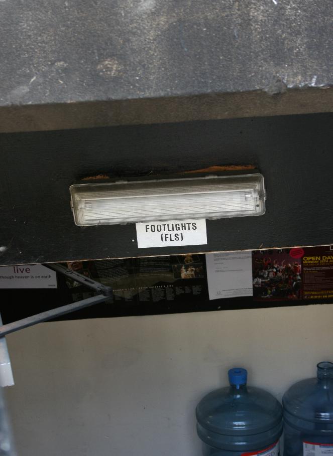 The glamorous entrance to the Footlights club
Because
of Christian religious restrictions on moneylending (which seem
strangely to have been forgotten nowadays) Jews had an essential place
in the medieval economy. As a major trading centre, Cambridge would
have had a sizeable Jewish population - before their expulsion from
Cambridge in 1275 they were based mainly in the region between All
Saints Church and the Round Church, an area subsequently known as Old
Jewry. Hence All Saint's Passage was once called Jews' Street, Vico
Judaeorum or Pilats Lane. Queen Eleanor, widow of Henry III, demanded
that all Jews be expelled from land she owned, which included Cambridge,
so in 1275 after various pogroms (including a particularly violent one
in 1266) they were deported to Huntingdon before being expelled from
England altogether in 1291. The Passage was also once known as Dolphin
Passage, named after a famous inn. The Dolphin Inn was a favourite of
undergraduates - a playright fellow, Thomas Randolph (early 17th C),
referred to students studying mainly at Mitre College and the
Dolphin Schools - the Mitre being another popular inn (but not
referring to the present pub called the Mitre, this one was on King's Parade). The church of All
Saints in the Jewry which gave the passage its current name was
demolished in 1865 as it jutted out over the pavement of Trinity Street,
which made it very narrow at this point. The churchyard remains, and is
often used for craft fairs (basically whenever there's likely to be a
large enough population of tourists in town to warrant it). The church
was rebuilt on Jesus Lane, opposite Jesus College, which gave rise to
its popular nickname St.Opposites (it is for this same reason
that Sidney Sussex College is often referred to as Sidney Sainsburys).
 All Saints', Jesus LaneThe new All Saints is no longer used (other than as an occasional rather
uncomfortable venue for music and plays, and for pottery
exhibitions). It is a handsome church, and some of the interior
decoration is by the William Morris company, but the local church-going population
is too small to keep it open. As it is no doubt a listed building it
will probably be left to fall down of its own accord, and some
monstrosity then put in its place.
All Saints', Jesus LaneThe new All Saints is no longer used (other than as an occasional rather
uncomfortable venue for music and plays, and for pottery
exhibitions). It is a handsome church, and some of the interior
decoration is by the William Morris company, but the local church-going population
is too small to keep it open. As it is no doubt a listed building it
will probably be left to fall down of its own accord, and some
monstrosity then put in its place.
Arbury and King's Hedges
Estate Agents commonly refer to
this area as "North Chesterton", because it doesn't have a good
reputation. If you are looking for cheaper city housing (although no
housing in Cambridge can really be called cheap)
then 90% of the properties you will be offered will be in this area. It's
not that it's a particularly large area, but it's obvious that a lot of
people want to move out. It's actually not as grim as most people would
expect, but then most people have clearly never been there. Certainly
it's a lot more pleasant than edge-of-town housing estates in most other
cities of this size. The current drift of City planning is to extend the
residential area eastwards, and much development is taking place in the
region of King's Hedges Road. Sainsburys wished to build another large
shopping complex here, and went to ridiculous lengths to drum up
support, but there was considerable opposition based on the inadequacy of
the roads in the area to handle the increased traffic. Iron Age remains
(the name Arbury means earthwork) and a large Roman villa have been found
here, and it is clear that the
area was the major source of agricultural produce for the Roman town on
Castle Hill.
The area south of the river
to the east of the City centre is called Barnwell, the name meaning
Children's Well (although other possible derivations have been proposed,
eg Warrior's Well). It was the site of two of the major early (Norman)
religious foundations. The first and more important of these was
Barnwell Priory, and the second was the Leper Hospital of St.Mary
Magdalene. Little of either remains: of the Priory there is not much
more than an outhouse - the Cellarer's Chequer (on Priory Road), and a lot of relevant street
names (Priory Road and Abbey Road are obvious, Beche Street is named
after Sir Everard de Beche, an early benefactor of the Priory (and, I'm
afraid, notorious anti-Semite even by the standards of his day). The
Frater Hall is on the site of the Frater, an old word meaning
refectory, or dining hall). The Priory was for several centuries second
only to Ely Cathedral in importance in East Anglia, the Bishopric of Ely
being founded only 5 years before the Priory. The Abbey was sold off and
destroyed at the dissolution of the monasteries by Henry VIII in 1539, stone
from its buildings being reused all over the city. Abbey House once had
the reputation as the most haunted building in England, with 6 different
frequently reported and distinctly unfriendly ghosts. Of the Hospital
only the Chapel remains, sometimes known as the Leper Church. The
Hospital was reported empty by 1279. The Chapel has been used as an inn
and a stable as well as a chapel, and was extensively restored by the
Victorians. In Victorian times the area filled up with brickworks and
heavy industry, and acquired a considerable reputation for crime. It
contained the majority of the town's brothels (along
with Castle End, the area just north of Northumberland Street). The area
still has a fair amount of light industry hidden away, and the interesting
Industrial Museum on Riverside. The criminal reputation has not
entirely gone as Riverside is still one of the best places in town to
go if you want to get your car nicked. The brickworks were responsible
for the attractive distinctive grey-yellow bricks you'll find in older
houses all over the City. The large Railway Sidings site, along with the
Gas and Sewage works have been redeveloped. Large residential
buildings and a major supermarket development have appeared. A new footbridge is due to be
built between Riverside and the bit of Chesterton on the other side of the river.
The
first Botanical Garden was on the site of the gardens of the Austin
Friars, now the University's New Museums Site. It was only 5 acres, and
was rather cramped (and, apparently, plagued by jackdaws). The present
garden is south of the city on a site formerly known as Empty
Common. The original garden's gates are now on the Trumpington Street
side. Due to lack of money the eastern half was let out as allotments,
and only planted in the 1950's. Both the original garden and this one
are watered by Hobson's Conduit, which runs down the West side of the
new garden.
A shopping
mall-ette (should that be Petty Mall ?) which used to lie between St.Andrews Street and
Drummer Street Bus Station, demolished in 2006. Due to the University and
Colleges and the Council pushing development in different areas the City
ended up with two shopping foci in the
80's, Lion Yard with the
"Historic" City Centre (we know it's been there a long time, calling it
the Historic City Centre as the Council invariably does makes it
sound like a theme park - Cambridge World, the retail
experience), and the Grafton Centre. Bradwell's
Court was used as a
thoroughfare in an attempt to bridge the two. Bradwell's Court was built in 1962 on the
site of what was Bradwell's
Yard (Bradwell was a local builder) and Christ's
Lane. Up on the side wall of Christ's next to Bradwell's Court
you could still see the old street sign for Christ's Lane, even though the street
itself disappeared - but it will reappear once the redevelopment is complete.
The
"bridge" in "Cambridge" is the Great Bridge (now more commonly known as
Magdalene Bridge) or, rather, a distant ancestor. The Romans probably
built a bridge on or near this site. Other bridges have followed, of
wood, stone, or steel. The Cam today looks relatively tame and easy to
cross, but before man came along it was wider and shallower and edged by
fen and bog, making it extremely hard to cross. Thus the relatively
solid ground in this area made it not just the best but the only place
to cross either by ford or by bridge what was quite an effective
geographical boundary. Not surprisingly, a town appeared. The Cam is
now well supplied with bridges of various kinds, but this is only
recently the case. Apart from the Great Bridge most river crossings
before the Edwardian period required a ferry, of which there were
several. From West to East these were: Bate's Ferry on the site of
Victoria Bridge; a ferry by the Fort St.George replaced by a footbridge
in 1927; Dant's ferry replaced by the Cutter (aka Pye) footbridge
(between Pembroke and Emmanuel Boat Houses - rebuilt in 2005); the
Horse Grind ferry at
Chesterton by the Green Dragon pub; B.Jolley's ferry from the Pike and
Eel pub; and the Ditton Plough ferry. All of these were so-called
"Grind" ferries, they were pulled across by a chain wound by hand. The
Horse Grind ferry was unusual in that the grind was powered by a horse,
hence the name. This ferry was the main ferry used for wagons and
livestock, with another separate ferry for pedestrians. The adjoining
road is still called Ferry Lane despite the fact that the footbridge has
been there for over 60 years (since 1935) - similarly there is still a
Ferry Path leading to the Fort St.George footbridge. There was a major
accident at the Ditton Plough ferry in 1905 when drunken undergraduates
tried to climb aboard an already full ferry after the May boat races. It
overturned and three women were drowned. The absence of a ferry or
bridge on this site means that Fen Ditton is probably harder to get to
from the town centre now for cyclists or pedestrians than it was in
Edwardian times and before. 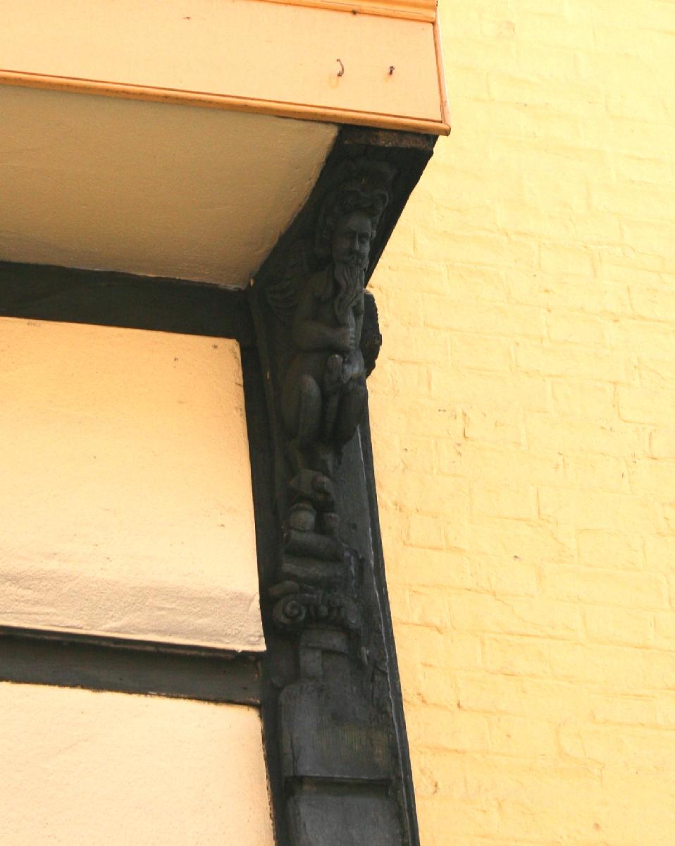 The area of the city around St.John's and Magdalene
Colleges used to be full of little streets like Portugal Place. They
were demolished either by these Colleges for modern extensions or by the
City Council for the Park Street Car Park. Only Magdalene comes out of
this with any credit as it had its new court designed by Edward
Lutyens, and only one of Lutyens buildings was in place when the college
ran out of money - which preserved the Tudor buildings along Bridge
Street. Most of these were brothels at one time or another, they
certainly were when Defoe visited the city in the 18th C - the shop
now occupied by Bowns (which is, I'm told, one of the best up-market
ladies clothing outlets in town) was once the Cross Keys Inn.
If you look
closely at the outside you can still clearly see the carved wooden
gargoyles (see photos), certain large anotomical features of which leave you in
no doubt as to what went on in there! For a long time these buildings
were in danger of being shaken to bits by the ludicrous weight of traffic
down Bridge Street.
The area of the city around St.John's and Magdalene
Colleges used to be full of little streets like Portugal Place. They
were demolished either by these Colleges for modern extensions or by the
City Council for the Park Street Car Park. Only Magdalene comes out of
this with any credit as it had its new court designed by Edward
Lutyens, and only one of Lutyens buildings was in place when the college
ran out of money - which preserved the Tudor buildings along Bridge
Street. Most of these were brothels at one time or another, they
certainly were when Defoe visited the city in the 18th C - the shop
now occupied by Bowns (which is, I'm told, one of the best up-market
ladies clothing outlets in town) was once the Cross Keys Inn.
If you look
closely at the outside you can still clearly see the carved wooden
gargoyles (see photos), certain large anotomical features of which leave you in
no doubt as to what went on in there! For a long time these buildings
were in danger of being shaken to bits by the ludicrous weight of traffic
down Bridge Street. 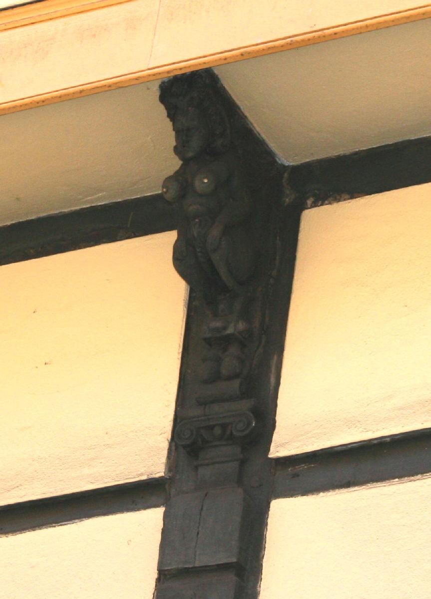 From January 1997 the council experimented
with closing Bridge Street to most traffic, which has made the situation more
tolerable.
From 2001 the street had an extensive facelift, and in particular
one pavement has been planted with attractive inset brass
flowers (Marguerites apparently) as a "street art"
project (made by Michael Fairfax), with new bollards and a large decorated brass
pillar (also by Michael Fairfax) at the Castle Hill end.
The facelift continued - until recently all the shops were painted white which
had gradually weathered to a dingy blueish-grey. In 2005 they were all
painted in a range of pastel colours - it makes the street look like a washed
out Ballamory, but is a great improvement. Bridge Street has
curiously metamorphosed into a major concentration of assorted restaurants
over the past few years, with many more than a dozen in the short distance between
the Round Church and the bottom of Castle Hill.
Unlike for example Mill Road, which specialises in curry houses, there are numerous ethnicities
represented with a good tapas restaurant, an excellent Japanese
restaurant and a very good Vietnamese place, among others. There are several others which
should be avoided at all costs, but I'd better not say which in case they sue ! Portugal Place
contained the original Book Shop and Art Gallery
of Gordon Fraser, whose company is now well known for greeting cards.
Portugal Place gets its name from the Port once shipped in vast quantities
by barge to the nearby Quayside, and from there to College High tables.
From January 1997 the council experimented
with closing Bridge Street to most traffic, which has made the situation more
tolerable.
From 2001 the street had an extensive facelift, and in particular
one pavement has been planted with attractive inset brass
flowers (Marguerites apparently) as a "street art"
project (made by Michael Fairfax), with new bollards and a large decorated brass
pillar (also by Michael Fairfax) at the Castle Hill end.
The facelift continued - until recently all the shops were painted white which
had gradually weathered to a dingy blueish-grey. In 2005 they were all
painted in a range of pastel colours - it makes the street look like a washed
out Ballamory, but is a great improvement. Bridge Street has
curiously metamorphosed into a major concentration of assorted restaurants
over the past few years, with many more than a dozen in the short distance between
the Round Church and the bottom of Castle Hill.
Unlike for example Mill Road, which specialises in curry houses, there are numerous ethnicities
represented with a good tapas restaurant, an excellent Japanese
restaurant and a very good Vietnamese place, among others. There are several others which
should be avoided at all costs, but I'd better not say which in case they sue ! Portugal Place
contained the original Book Shop and Art Gallery
of Gordon Fraser, whose company is now well known for greeting cards.
Portugal Place gets its name from the Port once shipped in vast quantities
by barge to the nearby Quayside, and from there to College High tables.
At the first boat race between Oxford and
Cambridge, Oxford wore dark blue and Cambridge wore pink. For the second
such race one of the Cambridge oarsmen bought some light blue
ribbons. This is just as well as "Cambridge pink" doesn't have quite the
same ring about it, although I would love to see our boaties today
wearing pink with blue ribbons. As on so many occasions Cambridge has
here defined itself as "not Oxford". Porterhouse Blue is the famous
comic book by Tom Sharpe, which has defined the popular view of
University life for a generation now. It still has a ring of truth about
it, I'm afraid to say (although condoms are rather easier to get hold of
now...). Many assume it's based on Peterhouse because of the similarity
in names and its rather conservative reputation, but Sharpe was
actually an undergraduate at Pembroke.
Cambridge
used to be flanked by two large commons, the East field and the West
field. The West field is now the college backs and the residential and
University buildings around Grange Road. Parts of the East field remain
as Midsummer,
Stourbridge and
Coldhams Commons. Cows and horses can
still be found on all three of these (or could before Foot and Mouth),
which results in the bizarre collection of cattle grids and gates which
surround them. Cambridge was unusual in having two such fields, most
other English towns having one. Revenue from the West field went to
churches on the North of the river, while the East field funded the
southern churches. One consequence of the flanking fields was that the
town was critically short of dry building land for much of its history,
and so after the Acts of Enclosure (early 1800s) freed some of the
fields for building there was something of an explosion. This is why so
much of the housing around the city is so similar - most of it was built
within a short space of time.
Usually somewhere around the third
division. Desperate to move from the tiny and inadequate Abbey ground on
Newmarket Road (the last time I went about a dozen balls were lost by
being kicked out of the stadium !), but lack of money, a suitable site,
and enthusiasm from the council has put it all on ice. They are now
trying to raise the funding to rebuild on the current site. Probably most
well known now as the second favourite team of Nick Hornby (as in Fever
Pitch) - Hornby was an undergraduate at Jesus College. Among other
things Hornby tells of the habit of opposing team fans of gathering
in the adjacent allotments and throwing cabbages over the stadium wall
at the Cambridge fans. There is another football team in town - non-league
Cambridge City with a small ground
at Mitcham's Corner, more commonly used
for car boot sales than football. See - it's not completely flat
Much of this
film was actually made at Eton, which makes it a little confusing for
Cambridge residents and visitors trying to place the buildings. Trinity
Great Court is considerably larger than the court depicted in the film,
which makes Abraham's Great Court Run rather more impressive. Since the
film Trinity undergraduates have run round the court after their
matriculation dinner (with the clock chimes suitably slowed down) as a
sort of initiation ritual. The number of accidents caused by excessive
alcohol consumption (shame !) has lead to the suppression of the event
by the college authorities. The name "Chariots of Fire" has now been given
to a half marathon/fun run around the city.
This is a lot
funnier now than when the name was invented. In the old days you weren't
allowed to laugh about anything to do with God because he didn't have a
sense of humour, but she's got one now so it's ok. Actually it's just a
collection of pieces of land next to Christ's College (although
originally owned by Jesus College - "Jesus's Pieces" is just as funny,
but harder to say). Now it's known mainly as "the bit of green between
the town centre and the Grafton Centre". It sports extremely attractive
flower beds in summer, a small Bus Station, and most of the town's
collection of drunks and homeless people. The siting of the Bus Station
here caused major
protests, and not just from the University. Enlarging it caused further
major protests. It is now accepted that the City Council cannot expand
the Bus Station on this site, although it badly needs more room as it is
cramped and the surrounding roads are dangerous. The sensible option is
for the Coaches to arrive at a different site, and this will probably
happen one day when funding, a suitable site, and the political
initiative coincide (ie don't hold your breath). The Bus Station is
on Drummer Street - the name deriving from Drusemere, which means
muddy pool - the pool being fed by Hobson's Conduit. Christ's Pieces
now features the Princess Diana Memorial Rose Garden - not every
city resident (this correspondent included) approves of the expenditure of
large amounts of our council tax on this eyesore, although it does give
the homeless people who congregate here something to look at, and I'm
sure they think the money was well spent. It is frequently and
extensively vandalised.
Another local
boy made good - or very very bad depending on your point of view. He was
born in Huntingdon and subsequently lived in Ely. He was a student at
Sidney Sussex College, and later went on to become the City's MP
(1640). His subsequent career is well known and partially covered
elsewhere on these pages, so I wont go into it. What is less well known
is his fate after death. His body was exhumed from Westminster Abbey on
the Restoration (1661) and it was ritually hanged and beheaded at Tyburn
in London (roughly where Marble Arch is now). His body is probably
buried anonymously somewhere in that area but his head was passed around
through various supporters, for a long time being kept in a biscuit
tin. In 1960 it was gifted to Sidney Sussex College and it is buried in or near
Sidney Sussex Chapel in a secret location (known only to the Master of
the College and one other) as it is suspected that even today feeling
runs high enough for somebody to attempt to dig it up. No member of the
Royal Family set foot in the college until 1996, although it is
presumably now forgiven. There was a portrait of Cromwell in the dining
hall which was hidden behind a curtain, legend had it that this was in case
the Queen dropped in for tea. In fact the portrait was opposite the main window and
was hidden to prevent light damage. It has now been moved to a darker location
and replaced with a less valuable portrait which doesn't require a curtain.
Cambridge now has three, the
Grafton Centre multiplex, another multiplex just South of the Railway Station, and
the (excellent) Picturehouse. The
St.Andrews Street ABC closed in July 1997, and in July 1999 reopened as the
Picturehouse, an arts-oriented cinema above a pub (Wetherspoons Regal, reputed
to be the largest pub in Europe). In its later days as a
conventional cinema it was clearly struggling against the competition of the
multiplex. It did boast the biggest screens and so did well on
blockbusters, but clearly not well enough. It was once a concert venue -
most notably host to The Beatles in 1963. It was built on the site of
Ye Olde Castel Hotel, a very attractive building (photographs exist) which
burned down in 1934, despite being a favourite
haunt of the firemen from the firestation which was then less than a
hundred yards down the road. The Hotel was established in 1243
(partially rebuilt in 1620), so this was a considerable loss. The name
lives on in the Castle pub next to the cinema. The Arts
Cinema, Market
Passage, closed in June 1999. It was owned by the same organisation
that owns the Arts Theatre, and was sold off for redevelopment to buoy
up the loss-making theatre. It hosted a Film Festival every summer
which lasted for two weeks and was the third biggest in the country
(after London and Edinburgh). It was regarded with great affection by many,
despite becoming increasingly squalid - the building having been constructed
in 1866 and never properly maintained. It has now (2002) been redeveloped as
a bar. Cambridge has had a great many other cinemas come
and go. Marks and Spencers on Market Square is
on the site of the old Victoria, which was a vast art deco barn, and at one time the
Victoria Assembly Rooms. I was very fond of the old Victoria cinema, and maintained
a one-person boycott of Marks and Spencers when it was redeveloped that lasted for
all of 5 minutes before I succumbed to their extensive range of upmarket TV dinners
and reasonably priced cotton socks. The bingo hall on Hobson Street was once the Central,
later the Odeon. There was also the picturesque (pardon the pun) Kinema
on Mill Road (formerly Sturton Town Hall), recently demolished having
been derelict for years. The building on the corner
of Mill Road and
Covent Garden, now the Salvation Army shop, is on the site of the
Playhouse, the first purpose built cinema in Cambridge. If you look
at the Covent Garden side wall you can still see the grafitti cut into
the brickwork over the years by people queuing to get in. The Tivoli
at Mitcham's Corner has been through
many uses and is now a pub, for a while The Fresher and Firkin, but now
The Graduate.
These are the
swampy patches of land by the river around Fen Causeway and extending to
the Mill Pool, far too damp ever to have been built on. Sheep's Green
is fairly self-explanatory. Coe Fen may be a corruption of cow, but is
more likely a corruption of coo - middle English for Jackdaw. The level
of Coe Fen was raised by using it as a rubbish dump. Laundress Green
really was used by
college laundresses in the days when the best source of water for
washing was the river. Lammas Land relates to Lammas Day, the first of
August and the traditional harvest festival day, it's nothing to do with
Tibetan monks or South American ruminants. Many areas of green around
the town were designated lammas lands in law, that is they were common
lands for 9 months of the year, but for the sole use of their owners for
the remainder (Lammas Day being the day they changed ownership). The
so-called Deer Park on the other side of the river behind Peterhouse is just a
garden now - the last deer was eaten by the fellows of Peterhouse long
ago. There is a bathing station on Sheep's Green which has been in use
for centuries. It was originally men only and the tradition was to bathe
nude, ladies being punted past were supposed to avert their eyes. It is
now mixed, and many hardy users still bathe in the nude.
This is a
bleak windswept wilderness between Coldham's Lane and the Football
Ground, bisected by a railway line. Not much used by people, but the
horses, bunny rabbits and wild flowers seem to like it. Just over
Newmarket Road to
the North was the Leper
Hospital, and Barnwell
Junction. Sometimes used as overflow parking for
the Football Ground,
which I imagine is not appreciated by the wild flowers and the bunny
rabbits. It used to be used as an unofficial golf course (a lot of
rough, and not much green).
There are a lot of these,
they are all interchangeable. Apart from New Hall and Newnham. And
Homerton. And Peterhouse and Magdalene. And Hughes Hall and
St.Edmunds. And Girton. Ok, so they're all different, apart from
Fitzwilliam. If this document included College histories as well it
would be twice as long, so I've chosen not to include these, and to
concentrate on the City instead - but as the University and City are
historically and geographically intertwined there are numerous
references to the University and the Colleges.
There are many college buildings in Cambridge named Cripps', which indicates that
they were significantly funded by the Cripps' Foundation.
This was a charity established in 1956 by the Cripps family to fund
projects for Education, Health and the Church. The family made its money by
manufacturing parts of pianos, and later moved into car components and such
diverse fields as velcro manufacture and holiday resorts. It is probably
unfortunate that the Foundation was providing money during the late 50s and 60s
when the assorted architects of the UK were taking one of their periodic holidays
from aesthetic considerations. As a result the name is attached to some of the
ugliest buildings in Cambridge. What a good way to make sure people remember you.
How people in Cambridge get
around, mainly. It's flat, there's nowhere to park, students can't
afford cars. The City Council calls Cambridge "Cycle City" in an attempt
to appear eco-friendly. The County Council, who are in charge of such
things, impose cycle bans on various bits of street. Whether the
majority of people think this is a good thing or a bad thing is
submerged in the ferocity of the argument. Certainly the public
enquiries conclude it's a bad thing, but these are ignored by the County
Council, because they can. Many cyclists don't help their case by
ignoring traffic lights and not having lights at night. Stopping
cyclists at night without lights is a favourite hobby of the Police, and
quite right too. The most common source of argument on local newsgroups
is "who is the most stupid, cyclists or drivers ?" - the answer clearly
being "anyone who chooses to consider this a topic worthy of argument".
Everyone, cyclist or driver, is united in just one
thing - the foreign
language students who flock here in summer are a bloody menace and
shouldn't be allowed anywhere near a bike. Cycling three-abreast,
holding hands, the wrong way down a one-way street (which I have seen
more than once) may be amusingly continental, but is not going to endear
you to the locals and you may end up as amusingly continental road
kill.
The truly
wealthy people in Cambridge live around Newnham and West Cambridge or in
the Queen Edith's area. Many who
are merely extremely well off live in the area around De Freville
Avenue, between Chesterton Road and the river. This area mainly grew up
after the Victoria Bridge was opened. In its early days many of the
inhabitants worked in the Pye radio works. This large site was
taken over by the even larger site of Philips Electronics (and subsequently an offshoot, Sepura), occupying
much of the southern half of Chesterton.
Excuse me a lengthy rant, but this is something
that is on my mind. A fairly constant theme of these pages has been the
destruction and rebuilding cycle that has taken place in Cambridge over
the centuries, exactly the same as in every other European city of any
age. This has taken place on the small scale, with individual buildings
being replaced, and on the larger with whole areas being
redeveloped. Usually the change is not for the better, but this is often
a little unfair. The ancient Three Tuns pub
on Castle Hill was knocked
down in the early 1900s and replaced by a mock Tudor pub. Dreadful, we
would think today - but the pub had never been maintained properly over
the centuries and was on the verge of falling down. If it had survived
into the age of listing (Note for non-English readers, buildings of
historical or architectural merit can be listed, which either
means they must be preserved entirely or restored using matching
materials, depending upon the degree of listing, grade 1 being the
highest) then the owner would have been forced to replace every brick to
stop it falling down, in which case it might have become more Disney
medieval than genuine. Tree Court at Caius College replaced some
attractive and solid but not particularly memorable houses and has given
rise to the range facing the Senate House, which is almost as iconic of
Cambridge as King's Chapel. The chapel itself was fronted by houses at
one time, which would have spoiled all those millions of tourists'
photos. So some development is worthwhile. Larger scale developments on
the other hand are often not. Lion Yard is
completely unforgiveable, and
one hopes that the same development would not be allowed today. The
whole area behind it is becoming (as of mid 2005) the Grand Arcade development but
there is little of any merit left in this area to mourn, although if
they removed the ugly modern canopy from Robert Sayle it would be
revealed as an attractive Edwardian shopfront (which is expected to be
retained in the Grand Arcade development I'm glad to see). Another attractive
Edwardian building on this site was destroyed to build the hideous
Norwich Union building on the Downing Street/St.Tibbs Row corner - they
preserved the statue of cherubs from over the door and it sat
somewhat incongruously over the new entrance. This building was in turn
demolished to build the Grand Arcade.
This is a word which is mainly used
outside of Cambridge. Inside, these creatures are more commonly known as
Fellows, ie the senior members of the colleges. From the Latin
Dominus (Master). They are, despite popular opinion, a mixed
bunch: young, old, male, female (and in some cases both !), and from a range of social backgrounds.
I am one myself. Many are quite mad. They tend to live to a great age, which just goes to
show that you should ignore Doctors when they tell you that a diet of
Port and Creme Brulee is bad for you.
Don't.
Cake shop on
Trumpington Street. The best Chelsea Buns in the known Universe. They
briefly opened another branch on Regent's Street, but it didn't last
very long. Fitzbillies suffered a major fire in 1998,
reopened on an adjacent site for a while, but has now moved the shop
back while retaining the adjacent site as a restaurant.
Founded
in 1816 by a bequest of Richard 7th Viscount Fitzwilliam. The collection
was moved around between various temporary quarters while the University
decided what to do with it. The present building was finally built in
1848. The architect, Basevi, didn't live to see it as he fell from
scaffolding while working on the maintenance of Ely Cathedral. For
about 20 years from the mid-70s shortage of money meant that the Museum was open on a
"split-shift" with the upper and lower parts of the collection not open
at the same time. This extremely annoying situation finally ended in
1996. It receives 250,000 visitors annually, and should by rights
receive more as it contains some wonderful things. One guidebook reports
a local legend that the lions at the entrance awake at midnight and
prowl the streets looking for children still awake. Just the sort of
legend that is designed to keep children wide awake all night and turn
them into axe-murderers. Of course, if it was true, the lions would be
permanently stuffed with undergraduates from Peterhouse and Pembroke
(not that many are particularly digestible). There were decorative ponds at
the front until the 2005 remodelling - they were originally dug as water
reservoirs to be used in the
event of incendiary bombs dropping on the museum during WWII.
A small village to the south
east of the city which is known mainly for the large psychiatric hospital on
its outskirts. For this reason the pubs of Fulbourn tend to be full of
mad people who smoke and drink too much, ie Doctors. Fulbourn is the
site of the wells that provide the City with water.
See also Parker's Piece and Cycling in
Cambridge. There are a great many schools here intended to teach the
young and wealthy of continental Europe how to speak English. This
might work better if they didn't cluster together quite so much, but
being free from parental supervision and young they
seem to spend much of their time studying Applied Gynaecology and
Advanced Lung Cancer. The students go back to their own countries having
learned a great deal about the British (mainly how we don't like them
very much), and thinking they know how to ride a bike. Apparently they
think we smell bad and eat too many potatoes, which is probably true.
When
Europe and the US were erupting in student protest in 1968, Cambridge
had its own little example - the Garden House riots. Students
encouraged by some notoriously left-wing fellows protested against a
"Greek Night" at the hotel (sponsored by the Greek Military Government
of the time) and ended up causing some relatively minor damage. The
whole situation was quite ugly, and in retrospect rather pathetic, and
ended up causing a lot of resentment against the University authorities,
who punished only a representative sample of those involved (ie those
who didn't run away from the Proctors fast enough !). The hotel is the
most expensive in Cambridge, but not otherwise interesting.
The first recorded
property on this site belonged to one Benjamin the Jew. The
building was granted to the town by Henry III in the 1220's. How it
became vacant and what happened to Benjamin is not known, it was well
before the official expulsion of the Jews from Cambridge (which was
itself some 20 years before they were expelled from the country
altogether). Part of it was used as the town gaol, an adjoining
synagogue (Benjamin clearly being wealthy) was leased to the Franciscan
order. The Franciscans moved some 50 years later to a purpose built
convent on the site of what is now Sidney Sussex College. The vacated
premises became the Town Hall, or Tolbooth as it was more commonly
known, its principal function being the disposition of tolls for entry
into the town and trading at the market. The building was raised on
arches with the market stalls below (the
present Market Square being
largely filled with buildings at that time which were not cleared until
the great fire of 1849). A Shire Hall was built on the open space in
front in 1747, again on arches with stalls beneath. The Shire Hall and
the Tolbooth were connected by a wooden bridge over an alley (Butter
Row, containing stalls which sold dairy produce, surprisingly
enough). After new Law Courts were built
on Castle Hill in 1842 the
Shire Hall and the new Town Hall (built in 1782 on the site of the old
one) were amalgamated into a Guildhall. The current Guildhall was built
on the site of these twin buildings (along with a few other adjoining
houses) in the 1930's. It was constructed in two parts, and if you look
closely at the front you can just about see a line where the bricks don't
match. It is not particularly attractive, but it is listed (which is just
as well given the architectural delights that the
cash-strapped council would no doubt visit on us otherwise). The council
is thinking of ways of turning the lower reaches into shops - perhaps
they should raise the whole lot up on arches and stick market stalls
underneath - there is historical precedent.
Gog and Magog are, of
course, the names of giants from the Book of Revelations who storm
around on the Day of Judgement destroying things. When they get here
they're going to be pretty pissed off to find they have an inconspicuous
blink-and-you'll-miss-'em range of low hills just south of the City
named after them. The hills got this name because of the large phallic
pre-Saxon figure once cut into the turf (as at several other famous
sites in southern England), who was christianised into the Biblical
giant. He's apparently still visible if you know what you're looking
for, but is very overgrown. An iron age camp, Wandlebury, was situated
on top.
It's large, it's ugly, and large parts of it were vacant for a very long
time after it was built. It's now home to many typical mall shops and seems
to be permanently full of surly teenagers. It has now grown an extension
which houses a multiplex cinema specialising in films that appeal to surly teenagers.
There are plans to extend it further by knocking down many of the shops on the
North side of Burleigh Street. Sources differ as to where the name comes from:
one says it is named after the man who first bought gas lighting
to Cambridge, John Grafton, from his works on nearby Maid's Causeway; another
says that it was named after the Duke of Grafton, a property owner in the area. As the
family name of the Duke of Grafton was Fitzroy and as the Grafton centre
stands on Fitzroy Street the latter explanation seems more likely. Augustus
Henry FitzRoy, 3rd Duke of Grafton, was briefly Prime Minister (1768-70) and also
Chancellor of the University (also from 1768).
This is a small
village just south west of Cambridge. Most of the houses were built to
house workmen and college servants. Now very rich people live there. It
has several very nice pubs, a few picturesque thatched cottages, and
pleasant walks along the Cam where you can watch people falling off
punts. It also has the Orchard, which is an orchard - which also has a
tea shop and a lot of deck chairs in which people lounge and read
newspapers when the weather permits. A civilised place with a long
history of distinguished loungers. Grantchester is also the home of
novelist (?) and Tory (??) Jeffery Archer, about whom I had better
say nothing. Lord Archer lives in Granchester Vicarage, once the lodgings
of the poet Rupert Brooke, who wrote a well known poem about the place
("and is there honey still for tea ?" etc). His reference to the church
clock standing still is not just a reference to the timelessness of the
place but to the fact that the clock stuck (but not at 10 to 3, it was
altered to that as a sentimental gesture after Brooke died) for many
years. Slightly beyond Grantchester along the river is Byron's
Pool. This has long been used for bathing, Lord Byron was not the first
or last, but the name stuck fairly soon after he achieved fame. It was
once a Mill pond - probably the Mill that formed the location of the
story told in Chaucer's Reeve's Tale.
Great
St. Mary's, also known
as St Mary the Great or, technically, St Mary the Great with St Michael, or just GSM.
There has been a church on this site since 1205, the current building
dating from between 1478 and 1608 (the tower in particular took them a while).
It became the University Church and was used for meetings, debates and
degree ceremonies before the Senate House opposite was built in 1730.
University sermons still take place there regularly. Many of the major
figures of the Reformation preached here (along with the nearby St Edwards) - consequently
it was the scene of much Protestant burning and other assorted nastiness.
A friend and local artist, Issam Kourbaj has
a plan to build a wooden spire on top of the GSM tower, housing a Camera Obscura. This
will be called the Eye Cone. Everyone agrees it's a great idea, it just needs funding, so
go to Issam's website and click a few links to find out how to send him money. The
University Vice-Chancellor from 1545, Matthew Parker, originally wanted a spire added
when he had the tower rebuilt, but it was never finished. Parker, incidentally, has
been suggested as the source of the expression "Nosy Parker" because of a supposed
reputation as a busybody, but as the earliest recorded use of the term isn't
until 1907 this seems unlikely.
GSM is called "Great" St Mary after a Saint Mary who was particularly great, as opposed
to St Mary the So-So, St Mary the Entirely Average, and St Mary the Spectacularly
Insignificant. Actually, no, I made that bit up.
It is called "Great" St Mary to distinguish it from another St Mary down the road - the
church next to Peterhouse College which is consequently called Little St Mary, or
St Mary the Less.  St Mary the Less churchyard The church on this site was originally called St Peters - it briefly
became the lodging place of the first scholars in Cambridge who subsequently
moved next door and set up a college, hence the name "Peterhouse". In 1352 it
was rebuilt and rededicated to St Mary, which required the additional "Little".
The graveyard garden at the rear is particularly lovely - although it is neat and tidy
at the moment - it was until recently romantically overgrown which made it a secluded
jungle in the middle of town. This usage of "Great" and "Little" doesn't seem
to have made it to the US. It is common in this country - for example you will often
find paired villages, "Great Flabbiebotham" (3 houses and a pub) at the bottom of the
hill with "Little Flabbiebotham" (1 house and a pub) at the top. We also persist
in calling our country "Great" Britain, which doesn't necessarily imply that we're
best at everything.
St Mary the Less churchyard The church on this site was originally called St Peters - it briefly
became the lodging place of the first scholars in Cambridge who subsequently
moved next door and set up a college, hence the name "Peterhouse". In 1352 it
was rebuilt and rededicated to St Mary, which required the additional "Little".
The graveyard garden at the rear is particularly lovely - although it is neat and tidy
at the moment - it was until recently romantically overgrown which made it a secluded
jungle in the middle of town. This usage of "Great" and "Little" doesn't seem
to have made it to the US. It is common in this country - for example you will often
find paired villages, "Great Flabbiebotham" (3 houses and a pub) at the bottom of the
hill with "Little Flabbiebotham" (1 house and a pub) at the top. We also persist
in calling our country "Great" Britain, which doesn't necessarily imply that we're
best at everything.
This isn't a healthy place, never
has been. The traditional time for major illness is about 3 weeks into
Michaelmas term when scholars from all over the world congregate here to
exchange ideas and airborne viruses. It's also cold, damp and windy, and
in years past (and to a lesser extent still) prone to extensive
flooding. The common square fortress-like construction of the colleges
was designed more to keep the wind out than the students in - apart from
at Caius College where Dr.Caius designed a court with the south side
open specifically to let fresh air blow through, to clear the unhealthy
vapours. Hygienic practices left a lot to be desired by modern standards
- Trinity Lane is marked on some old maps as Pisspot Lane and there was
a Foul Lane (now swallowed up by Trinity College) which was effectively
an open sewer thought responsible for much illness at Trinity Hall. The
King's Ditch was used for the same purpose. Clean drinking water was in
short supply before the construction
of Hobson's Conduit and an earlier
piped water scheme that now provides the water for Trinity Great Court
Fountain. During the plague years (the Black Death 1349-1390, and
periodically for the next 300 years) Cambridge was often largely
deserted in the summer months as people fled to the countryside. Over
one third of the population died during the Black Death period of plague
or famine. There were pesthouses (temporary hospitals where
plague victims were taken) on Midsummer Common and later on Coldham's
Common. There is an apocryphal story that so many people died of the
plague in one street in central Cambridge that it was just walled off
and left. When the wall was taken down many years later the street was
green with grass, and hence became Green Street (Festering Corpse
Street was presumably outvoted). This did actually happen in other
parts of Britain (notably Edinburgh) but not here. Green Street was
named after the owner of the land when the first houses there were built - the
ends of the street were once largely blocked off by buildings, but it
was not walled up on purpose.
Cambridge has several peculiar place designations
beyond the usual streets and roads:
Sir Jack Hobbs (1882-1963) was a
cricketer, famous amongst those people with nothing better to do with
their minds than remember cricketers. His dad was a groundsman at Jesus College
and young Jack grew up in Cambridge. Parker's Piece was once the main location for both
town and University cricket (although the University has since moved to the adjacent
Fenner's ground) and the pavilion was named in his honour. The cricket pavilion has now
been converted into a restaurant. This used to be a very good creperie, run by the
lovely Mr & Mrs Hill, but they have now moved on to pastures new and the restaurant is a
lot less interesting than it was.
Thomas Hobson was a 17th Century
carrier, that is he transported goods, and sometimes people, between
Cambridge and London. He acquired a considerable fortune and gave much
of it to charitable works, such as
the Conduit and
the Spinning House. The well known phrase "Hobson's Choice" ie no choice at all, is
popularly derived from his practice of renting out the next horse in
line rather than allowing people to choose. However the phrase was in
contemporaneous use in some places as "Hudson's choice" so the story may
be an early urban legend. He was based in the George Hotel on
Trumpington Street, now part of St.Catherine's College, and specifically
his stables were on the site of the Chapel. Hobson's Street had no
connection to him at all, it used to be called Walls Street (although
Cambridge never had City walls, it wasn't big enough to warrant
them).
 Hobson's Conduit on Trumpington Street
Hobson's contribution to this is uncertain, he didn't instigate it, but he was
probably one of the several people who funded it. Why it acquired his
name is not known. Hobson's New River as it was sometimes called was
originally intended to flush out the sewage from
the King's
Ditch. Accordingly in the 17th century a stream running in from the
South of Cambridge called the Vicar's Brook was forked and some of the
water fed via a channel right down the centre of Trumpington Street to
the Ditch at the junction with Pembroke Street. This didn't work very
well for clearing the sewage but was very successful for providing
drinking and bathing water, and so two other forks were made from the
Conduit Head at what is now Lensfield Corner. One was piped down Tennis
Court Road and eventually to Market Square, where it emerged at a
monument also confusingly called Hobson's Conduit, and later at the
fountain. The other was piped down Lensfield Road and Regents Street
where it emerged into open runnels down St.Andrews Street and past
Christ's. Offshoots fed several college ponds and pools. The Trumpington
Road channel proved dangerous as people often fell in and it was
eventually diverted into the open runnels that still exist down either
side of the road. People still fall in, even when sober, I know I
have. The runnels along St.Andrews Street were covered over for a long
time, but have recently been marked by channels and nice iron covers,
and the water now runs along the gutter outside Christ's by the taxi
rank, especially so people climbing into the taxis get wet feet. The
monument that used to be in Market Square is now at Lensfield Corner,
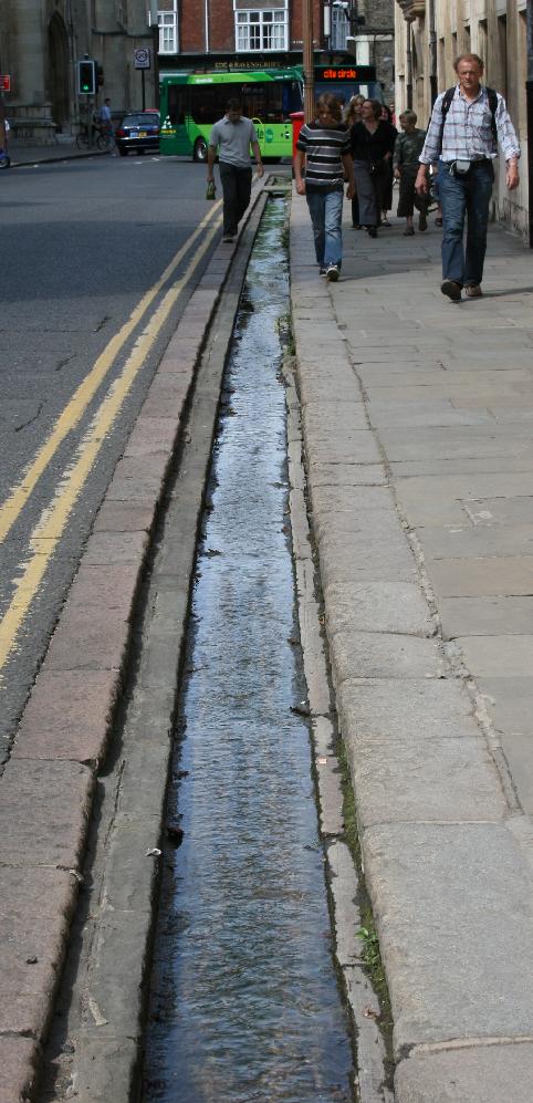
but there is occasional talk of moving it back.
Hobson's Conduit on Trumpington Street
Hobson's contribution to this is uncertain, he didn't instigate it, but he was
probably one of the several people who funded it. Why it acquired his
name is not known. Hobson's New River as it was sometimes called was
originally intended to flush out the sewage from
the King's
Ditch. Accordingly in the 17th century a stream running in from the
South of Cambridge called the Vicar's Brook was forked and some of the
water fed via a channel right down the centre of Trumpington Street to
the Ditch at the junction with Pembroke Street. This didn't work very
well for clearing the sewage but was very successful for providing
drinking and bathing water, and so two other forks were made from the
Conduit Head at what is now Lensfield Corner. One was piped down Tennis
Court Road and eventually to Market Square, where it emerged at a
monument also confusingly called Hobson's Conduit, and later at the
fountain. The other was piped down Lensfield Road and Regents Street
where it emerged into open runnels down St.Andrews Street and past
Christ's. Offshoots fed several college ponds and pools. The Trumpington
Road channel proved dangerous as people often fell in and it was
eventually diverted into the open runnels that still exist down either
side of the road. People still fall in, even when sober, I know I
have. The runnels along St.Andrews Street were covered over for a long
time, but have recently been marked by channels and nice iron covers,
and the water now runs along the gutter outside Christ's by the taxi
rank, especially so people climbing into the taxis get wet feet. The
monument that used to be in Market Square is now at Lensfield Corner,
but there is occasional talk of moving it back.
This was built
during the period when the Prince of Wales was making such a fuss about
new buildings sensitively matching older buildings in their
surroundings. The Hotel is basically a brick cube with architectural
details stuck on. Stuck on in the literal sense, they're made of
fibreglass - one of the columns on the front fell off shortly after it
was built. If you look at the back of the hotel, which sensitively
matches the architecture of the Lion Yard car park, you'll see that
there are several different brick colours used in bands. They were
clearly in such a hurry to throw up this carbuncle that they couldn't
even be bothered to use matching brick types. An Architecture text book
I once saw used this building as an object lesson in what not to do. The
sooner it falls down, the better. The only good thing about it was that
nothing was demolished to clear the space, the buildings that used to
exist here (the old Corn Exchange and the Masonic Hall) went long
ago. The area used to be an open space called St.Andrew's Hill, and it
was Cambridge's second major marketplace, specialising in animals (known
as the beast market or hog market at various times). The town abbatoir
was on Slaughterhouse Lane, now Corn Exchange Street, the former home of
the University Computer Lab. Coincidentally, the New Museums Site next door to
the Holiday Inn was built on the site of the Old Botanical Gardens, and
these were on the site of the gardens of the Austin priory, known as
Holiday's Gardens. The Holiday Inn has recently been renamed the Crowne
Plaza.
It is quite obvious
to any visitor that Cambridge has a larger number of homeless people
than you would expect for a town of its size. In fact it has the third
largest number of homeless people per capita of any town in Britain,
after London and Oxford. The reason is that the large number of tourists
and students are a ready source of income. The boozy, boorish students
are a small minority, a large number of them have a clear idea of how
well-off and privileged many of them are, and they do give
generously. Furthermore Cambridge is a nice, attractive, prosperous
place with full employment, and if you are homeless and rootless then
it's better than most cities you could name. Unfortunately it is also
cold and damp, and there are not as many shop doorways or other
sheltering places as in the larger cities, and the hostels are
invariably full. Government initiatives and the activities of Shelter,
the homeless charity, and the Big Issue have helped a lot (and at the
risk of sounding party political the current Government deserves more
praise for this particular achievement than it gets). Unfortunately the
initiatives tend to focus on London, which has the most visible problem
(it has 20% of the national homeless total but receives 80% of the
funding). The charity Wintercomfort does its best in the Cambridge area,
and does very well. However, its activities have been hampered by what
many see as heavy-handed treatment by the Police. In 1999 the Director
of Wintercomfort, Ruth Wyner, and a Day Centre Manager, John Brock, were
sentenced to 5 and 4 years respectively for not informing the Police
that drug trading took place on Wintercomfort premises. Their not unreasonable
claims that they weren't there when it took place and didn't know the
extent of it, and that even if they did then shopping the very people
they were trying to help to the Police was hardly a way to win their
trust, were ignored. They became known as the Cambridge Two, and a
national campaign was started to press for their release and for a
change to the drug laws to prevent this sort of stupidity from happening
again. In July 2000 their sentences were cut at appeal and they were
both freed, but their convictions have not been overturned. I have
tended not to put links in this document as they go out of date too
quickly, but these are I think worthwhile: Wintercomfort
and The Cambridge Two.

Humour
Pembroke College seems to have
had more than its fair share of comedians: Tom Sharpe, Clive James,
Peter Cook, Eric Idle, Tim Brooke-Taylor and Bill Oddie were all
there, as was the cartoonist Martin Rowson. Other well known funny Cantabridgians include Jonathan Miller,
John Cleese, Douglas Adams, Michael Palin, Terry Jones, Graham Chapman,
Graeme Garden, Steven Fry, Hugh Laurie, Griff Rhys Jones, Sandi Toksvig,
Rory McGrath, Tony Slattery, Rob Newman, David Baddiel, Mel Giedroyc, Sue Perkins,
David Mitchell, Robert Webb and probably many more too funny to mention.
Many of these first practised their trade as members of
Footlights, which also produced Emma Thompson, and many many others. A recent and
unlikely Cantabridgian is Ali G (aka Sacha Baron-Cohen/Borat).
A recent
survey revealed that Cambridge has the 6th highest gay population in England and Wales, after
Brighton, London, Manchester, Blackpool and Bournemouth (yes, Bournemouth).
Quite surprising for a little town in the fens. Oxford came 9th. How
they arrived at these figures was not mentioned - I don't remember being asked at the
last census, perhaps they just guessed. Tracking sales of Cher albums perhaps, or
counting the Birkenstocks and dividing by two (jokes copyright to "stereotypes.r.us.com").
Do bisexuals count as half ?
An area just North of Parkers
Piece and South of Maid's Causeway/Newmarket Road that includes the
Grafton Centre, and is vaguely kite-shaped. It used to consist almost
entirely of small attractive Victorian houses of the sort that still
surround Mill Road, and which now command ridiculously high
prices. Instead a large part of it is now covered in ugly modern
shopping centre. Older city residents still mourn the restaurants gone
from this area, particularly Waffles. The area was afflicted with
planning blight for a long period before the bulldozers moved in. There
are still some very good pubs here, eg The Tram Depot and the Free Press.
The King's Ditch followed a
line curving South from the Cam by Magdalene College, along Park Street, across the
back of Sidney Sussex, along Hobson Street, across Lion
Yard and its car park, and down Pembroke Street and Mill Lane back to
the Cam. This was the
fortification that marked the southern boundary of medieval Cambridge, and was
largely built by Henry III. The river marked the other boundary,
although there was an additional military encampment outside the
boundary around Castle Hill. A
Roman road (called the Via Devana in
some histories, but that name is an 18th century invention) approached
along what is now Regents Street and St.Andrew's Street to a (probably
wooden) gate in the ditch, the Barnwell Gate. There was another gate at
Trumpington Street, and another roughly where Magdalene Bridge is now,
from which the Roman road continued on what is now the Huntingdon
Road. Space inside the medieval Ditch was limited as much of the land by
the river was too wet for large buildings, so several of the early
colleges were built just outside, eg Peterhouse and Pembroke. The Ditch
was open to the Cam at either end, but wasn't deep enough to flood
throughout so by the Elizabethan period became an open sewer running
through the expanding town. Hobson's Conduit was originally conceived as
an attempt to flush out the ditch, for which it proved largely
unsuccessful. The Ditch was never much use as a defence, but it did
serve to channel traders through one of the town gates if they wished
to visit the markets at Market Hill and Peas Hill. This made it much
easier to collect a toll. It was filled in in stages during the late
17th Century. Portions of the ditch were uncovered during the 2005 archaeological investigations prior to the building of the Grand Arcade. The existing ditch around the back of Jesus College was an
offshoot.
Along with Market
Square and the Rose Crescent McDonalds this is the only bit of
Cambridge most tourists
get to see. Surprisingly some of the shops are still useful to residents (I'm a particular
fan of Nomads). Recently resurfaced and generally tidied up. Once the main route through
the city, it is now
blocked off (with rising bollards to allow buses through) at Senate House Hill.
At night both streets are remarkably dim due to the strange vertical streetlamps (Richardson
Candles, produced for the Festival of Britain in 1951) which don't work very well, but
which look nice. The railings outside the Senate House are among the oldest iron railings in
the country, which is why they weren't melted down to make tanks during the war like
so much other public ironwork. Undergraduate exam results are posted on boards outside the
Senate House, but the gates in the railings are only open in the daytime, with the result
that late arrivals keen to know their results have been known to climb over. I mention
this only because there's a particular railing against which I still hold a grudge having
nearly impaled myself upon it.
A remarkable number of
pubs for such a short road (5 at present), but there used to be three
times as many. A pub crawl along the street was known as the King Street
Run, hence the pub by that name. Many record shops. Unfortunately the
Garon book and CD shop has recently (2001) closed down, and the even
more excellent Parrot Records is now an ex-Parrot, due to competition
from other discount record shops such as Fopp. Several of the shops
have a distinctively Italian feel,
most particularly the lively if somewhat nicotine-encrusted Clown's coffee
bar (which received a large proportion of my student grant). Most of
the shops underneath the building at the back of Christ's (known as
"the typewriter" for reasons that are apparent if you look at it from
inside the college) were vacant for four or five years after it was
rebuilt in the early 90's. Occupied shops, no matter what they sell, do
more for the character of a town than empty ones, but empty shops can
presumably be written off against tax. Most of these shops have now
been taken over by Giulio's, which mainly sells designer menswear - there
are several other excellent shops of this type making King Street the place to go
for interesting menswear. The road also features the residential
building at the back of Sidney Sussex, which is remarkably unfortunate.
The alley next to what used to be Garon, Milton's Walk, was the scene of a notorious and
grisly murder in 1921 (Alice Lawn, a shopkeeper from King Street) and
was subsequently long known as Cut Throat Alley. The road was named for W.King of
King and Harper, originally a bicycle repair business in Sussex Street,
but later manufacturers of motorcycles (and prize winning ones at that,
the Harleys of their day, the early 1900s). King himself won many
international races.
Not in itself particularly
interesting unless you are a chemist - the huge and ever expanding University Chemistry
department takes up most of the South side. The two ends, however, have unusual names.
The Regent Street end is called Hyde Park Corner, despite the fact that there is not
and has never been a park here, called Hyde Park or anything else. There is a theory
that there was once a house on the corner owned by a woman called Peck who later
married someone called Hyde. So it is really Hyde-Peck corner, the similarity to
Hyde Park corner in London causing the name to change. I find this totally unconvincing.
The Trumpington Street end is known as Spittle or Spital End. This is a common
medieval abbreviation of hospital (hence Spitalfields in London on the site of
St.Mary's Spital). The hospital in this case was St.Anthony and Eligius, the
last parts of which were demolished in the mid nineteenth century. The name Lensfield
Road itself simply derives from John Lens, a local landowner.
 Like any English town with
a long history, Cambridge used to sport a vast number of coaching inns
(far more than most towns of its size - the city is still over-supplied
with pubs). The Eagle and the Baron of Beef/Mitre (now two pubs either side of an archway, inside can still be seen the sign Blackmoor Head Yard)are still just about
recognisable as such. One of the most famous was the Red Lion. This fell
gradually into disrepair and closed, and the other shops on the south
side of Petty Cury likewise emptied. They were replaced with a
characterless small shopping mall called Lion Yard, now universally
disliked (even after its recent refit). Rumours of collusion between
the Council and the developers were rife at the time. Before the security
gates were installed it was where the drunks went when it was too cold to
sit on Christ's Pieces, now they use the Bus Station. There is a well
hidden and rather desolate roof garden which was intended to symbolise
friendship with Cambridge's twin city of Heidelburg - a pretty poor
symbol. There is also one of Cambridge's few nightclubs, currently called
5th Avenue, formerly going by the unwieldy Cindarella Rockafellas (or
Cindy's as it is still commonly known), and before that as
Ronelles. The name changes every few years, but the club doesn't - a
sweaty meatmarket with a tiny dancefloor. Somewhat more hospitable to
students than the other central discos, which is either a good thing
or a bad thing depending on your point of view. Several other ancient
inns were demolished as part of the same development, most notably the
Falcon. Queen Mary (Tudor) watched a play held in the yard there (and
enjoyed it greatly, so the story goes, so presumably it involved killing
Protestants). Much more recently a party in the Falcon to launch a
poetry magazine was the meeting place of Ted Hughes and Sylvia Plath (he
had just left Pembroke, she was on a scholarship to Newnham). Plath
planned a novel based on her time in Cambridge, to be called Falcon
Yard, but it was still unfinished when she had her tragic appointment
with a gas oven. The shop on the Sidney Street corner (for a long period
Dorothy Perkins) was the
site of the town Post Office before the redevelopment (one of the sites,
it has moved around quite a bit over the years, gradually increasing in
size). This was built on the site of yet another large and famous old
coaching inn, the Wrestlers. St.Tibbs Row at the back of Lion Yard is
now almost entirely buried by the Lion Yard Car Park. It used to be a
major thoroughfare boasting several major Inns and pubs, most notably
The Bun Shop (the name of which has moved around the city and is now
attached to an establishment on King Street). St.Tibbs Row
will be the site of a major city centre shopping development, Grand
Parade. This may be saved from
Lion Yard style mediocrity by the fact that much of the floor space
will be occupied by a new Robert Sayle (aka John Lewis) department store.
Like any English town with
a long history, Cambridge used to sport a vast number of coaching inns
(far more than most towns of its size - the city is still over-supplied
with pubs). The Eagle and the Baron of Beef/Mitre (now two pubs either side of an archway, inside can still be seen the sign Blackmoor Head Yard)are still just about
recognisable as such. One of the most famous was the Red Lion. This fell
gradually into disrepair and closed, and the other shops on the south
side of Petty Cury likewise emptied. They were replaced with a
characterless small shopping mall called Lion Yard, now universally
disliked (even after its recent refit). Rumours of collusion between
the Council and the developers were rife at the time. Before the security
gates were installed it was where the drunks went when it was too cold to
sit on Christ's Pieces, now they use the Bus Station. There is a well
hidden and rather desolate roof garden which was intended to symbolise
friendship with Cambridge's twin city of Heidelburg - a pretty poor
symbol. There is also one of Cambridge's few nightclubs, currently called
5th Avenue, formerly going by the unwieldy Cindarella Rockafellas (or
Cindy's as it is still commonly known), and before that as
Ronelles. The name changes every few years, but the club doesn't - a
sweaty meatmarket with a tiny dancefloor. Somewhat more hospitable to
students than the other central discos, which is either a good thing
or a bad thing depending on your point of view. Several other ancient
inns were demolished as part of the same development, most notably the
Falcon. Queen Mary (Tudor) watched a play held in the yard there (and
enjoyed it greatly, so the story goes, so presumably it involved killing
Protestants). Much more recently a party in the Falcon to launch a
poetry magazine was the meeting place of Ted Hughes and Sylvia Plath (he
had just left Pembroke, she was on a scholarship to Newnham). Plath
planned a novel based on her time in Cambridge, to be called Falcon
Yard, but it was still unfinished when she had her tragic appointment
with a gas oven. The shop on the Sidney Street corner (for a long period
Dorothy Perkins) was the
site of the town Post Office before the redevelopment (one of the sites,
it has moved around quite a bit over the years, gradually increasing in
size). This was built on the site of yet another large and famous old
coaching inn, the Wrestlers. St.Tibbs Row at the back of Lion Yard is
now almost entirely buried by the Lion Yard Car Park. It used to be a
major thoroughfare boasting several major Inns and pubs, most notably
The Bun Shop (the name of which has moved around the city and is now
attached to an establishment on King Street). St.Tibbs Row
will be the site of a major city centre shopping development, Grand
Parade. This may be saved from
Lion Yard style mediocrity by the fact that much of the floor space
will be occupied by a new Robert Sayle (aka John Lewis) department store.
The distance from the front of the Guildhall to the back of the
Guildhall on foot is about 200m. It is said that the distance
by car thanks to one-way restrictions and blocked roads is about 3 miles.
The first car
to be driven in Cambridge, a Peugeot, was owned by the Hon.C.S.Rolls
(later to make rather nice cars himself with Mr.Royce) while an
undergraduate. If the town had known what the motor car had in store for
it he'd have been thrown out of the city before he could say "my other
car is a Porsche". Marshall, the catering manager of
the Pitt Club saw an
opportunity when the wealthy young members needed somewhere to have
their cars repaired and stored. Marshall's motor dealership and
other enterprises are now one of the city's major employers, along with
the University and Colleges (of course), and Phillips in
Chesterton. Phillips took over the Pye "Granta" radio
works. W.G.Pye's original employment was making scientific apparatus for
the Cavendish laboratories. Heffers is something of a local
institution. The main branch is not as big as Blackwells in Oxford, but
it's close. Not bad as Mr.Heffer was barely literate when he started his
business career. He originally managed a pub, despite being temperance,
but was loaned the money to start a small stationers and bookshop in
Fitzroy Street (nobody ever became poor by selling books in
Cambridge (actually I have recently been informed that this is not
true !) ),
and became a University Constable (commonly known as Bulldogs) to
earn a little more money. He sold hymn books at evangelical meetings and
thus raised enough money to expand. The firm has shops all over the
city, the main branch is in Trinity Street - their previous shop in
Petty Cury closed shortly before the Lion Yard redevelopment in the
early 70s. Heffers have recently (1999) been taken over by Blackwells but
will retain the name. There was a haberdashers on the site
of theEaden Lilley department store on Market Street since
1750. William Eaden took over the existing haberdashers, his daughter
later married David Lilley, and hence the name. It grew to cover a large
part of the area between Market Street and Green Street, but first sold
off its outlying sections to other shops and underwent a major redevelopment,
and then closed completely. The site has become a large bookshop (just
what Cambridge is short of), which I'm glad to see has kept Eaden Lilley's
hyper-efficient air conditioning system. There are still branches of Eaden
Lilley in other parts of East Anglia - for a while it reopened just its
delicatessen nearby, but this has now also closed.
 The Rose and Crown was a large Inn, Rose Crescent is built on what was
the back yard. It contains the Gardenia restaurant ("Gardies", a
popular late night haunt of the hungry insomniac - they do an excellent
vegetarian kebab), and a small McDonalds. The City Council managed to
keep McDonalds out of Cambridge for years, but as the previous occupant
of this site was also a restaurant (well, cooked food dispenser, anyway)
the Council couldn't oppose in this case as there was no change of
use. The owner of the Gardenia site, Caius College, is currently (Mar 2004) trying
to shut it down so they can turn part of it into student accomodation - an enormous
petition has been organised to oppose this, I'll keep you posted. French
Connection at the Market end used to be a tobacconist
(Bacon's, from 1810 to 1983, frequent haunt of many a famous
nicotinephile, eg Tennyson, Edward VII), and there is still a large
plaque there with "Calverley's Ode to Tobacco" to prove it.
The Rose and Crown was a large Inn, Rose Crescent is built on what was
the back yard. It contains the Gardenia restaurant ("Gardies", a
popular late night haunt of the hungry insomniac - they do an excellent
vegetarian kebab), and a small McDonalds. The City Council managed to
keep McDonalds out of Cambridge for years, but as the previous occupant
of this site was also a restaurant (well, cooked food dispenser, anyway)
the Council couldn't oppose in this case as there was no change of
use. The owner of the Gardenia site, Caius College, is currently (Mar 2004) trying
to shut it down so they can turn part of it into student accomodation - an enormous
petition has been organised to oppose this, I'll keep you posted. French
Connection at the Market end used to be a tobacconist
(Bacon's, from 1810 to 1983, frequent haunt of many a famous
nicotinephile, eg Tennyson, Edward VII), and there is still a large
plaque there with "Calverley's Ode to Tobacco" to prove it.
Calverley's
Ode to Tobacco
(written at Cambridge in 1852)
A tribute to this firm

Thou who, when fears attack
bidst them avaunt, and black
care, at the horseman's back
 perching, unseatest;
Sweet, when the morn is grey;
sweet when they've cleared away
lunch; and at close of day
 possibly sweetest:

I have a liking old
for thee, though manifold
stories, I know, are told,
 not to thy credit:
how one (or two at most)
drops make a cat a ghost -
useless, except to roast -
 Doctors have said it:

How they who use fusees
all grow by slow degrees
brainless as chimpanzees,
 meagre as lizards:
Go mad, and beat their wives:
plunge (after shocking lives)
razors and carving knives
 into their gizzards.

Confound such knavish tricks!
Yet know I five or six
smokers who freely mix
 still with their neighbours:
Jones - (who I'm glad to say
asked leave of Mrs J.-----)
daily absorbs a clay
 after his labours.

Cats may have had their goose
cooked by tobacco-juice:
still why deny its use
 thoughtfully taken?
We're not as tabbies are:
Smith, take a fresh cigar !
Jones, the tobacco-jar !
 Here's to thee Bacon !
For what is today a
rather undistinguished and tatty square this area has a long and varied
history. There used to be buildings behind Great St.Mary's, so Market
Hill was small and L-shaped. These buildings burned down in the great
fire of 1849 and the opportunity was taken to create the rectangular
area generally now known as Market Square. The original stalls were
mostly on the area occupied now by
the Guildhall, in arcades underneath
the Shire Hall. Hobson's Conduit stood close to what is now the
Guildhall, but when the Square was created it was moved to its current
site on Lensfield Corner. The railings around the Conduit were
traditionally used to tie criminals condemned to a public whipping. The
water from the conduit was used in a new fountain positioned in the
middle of the square. This fountain originally had a decorated stone
arch over it, but this was later removed to give the rather sad relic we
have today. There was also at one time a Market Cross (removed in 1786) from which public
pronouncements were read. It could also be used for public
punishment, a Mayor once insulted by an undergraduate asked that the
miscreant be nailed by his ear to the cross while apologising (the
request was later withdrawn, no doubt much to the undergraduate's
relief). The Duke of Northumberland here proclaimed support for Queen
Mary after his failed uprising in the name of his daughter, Lady Jane
Grey. It didn't work, Bloody Mary wasn't noted for her forgiving
nature. The market square also saw the bizarre burning of the Protestant
Scholar's coffins, and the more predictable burning of Luther's
books. The stalls in the market were kept in strict divisions, with one
area for meat, another for vegetables etc, rather than the random
distribution we have now. The City Council has repeatedly planned to
make Market Square more attractive, and recently had a competition to
chose a new fountain. The winner was a column with a gold ball on top
which water flowed over. I rather liked it but hardly anybody else
did. Popular opinion seems to be in favour of moving Hobson's Conduit
back, presumably into the centre of the square rather than to its
original position, and I don't suppose it'll be used for public
whippings. The Council also wants to re-cobble the Square, and put down
some test areas on the Petty Cury side. However, it then decided to
spend our Council Tax on the poor and needy and shelved all
redevelopment plans for the time being - leaving a rather confusing
patchwork effect. The Market stall holders would have had to move from
the Market Square during redevelopment and several plans were floated as
to where they would go, including King's Parade. They opposed it
strongly and breathed a large sigh of relief when the plans were
dropped.
When people
died of the plague, which they did here in great numbers as it has always
been an unhealthy place, they tended to be buried in large open pits
rather than in individual graves. Cambridge's early plague victims are
all under Midsummer Common (victims from the 1665 plague are at
Coldham's Common). In years past the County council has wanted to dig it
all up to build an underground car park, but that idea seems to have
disappeared (probably due to lack of funding rather than common sense
and local outrage). It is true that Midsummer Common is several degrees
colder than surrounding streets, probably due to being next to the river
and not anything to do with the hundreds of people anonymously buried
there. Site of the annual fireworks and Strawberry Fair. There is also
a rather boring fun fair in mid summer which is a descendant of the
original medieval Midsummer Fair, originally the fair
of Barnwell Priory
- not the same event as Sturbridge Fair, which was much larger. The
Common was once the property of the Nunnery of St.Radegund, part of
which now survives as Jesus College chapel. The Nunnery also had the
right to a fair, the Garlick Fair, which was held on open land by what
is now Park Street. Midsummer Common is also the site of the Fort
St.George (an excellent pub), and Midsummer House Restaurant. The full
name of the Fort St. George is "The Fort St.George in England" - after
10 pints of Guiness it helps to be reminded which country you're
in - the other Fort St.George is in Madras, India. Midsummer House
is the most notoriously expensive restaurant in Cambridge, and
holds an ever-increasing and apparently well earned number of Michelin stars.
An interesting public lavatory has just (2005) appeared at the South end of the
common - it looks like a huge copper woodlouse, and is apparently known as "the armadilloo".
You can tell how long
students have been here by how far they've travelled down Mill Road.
Very, very few have even made it as far as the railway bridge. (This
doesn't include students from Hughes Hall, who live there, which is
cheating). It is narrow and overburdened with traffic, and hence one of
the most polluted streets in Britain, and very dangerous for
cyclists. The roads branching off contain many of the most expensive
houses per square foot in town, which just goes to prove that given the
choice people really want to live in tiny Victorian shoe boxes with no
gardens and no parking. Mill Road hosts many of the more interesting
shops in town, including the famous Arjuna, a health food shop of long
standing, and the Curry Queen. This is often said to be the best Indian
Restaurant in town, but in my opinion a) this isn't saying much, most of
them are not that good, and b) the non-smoking section is two small
tables next to the toilets so it doesn't get much patronage from me.
The Golden Curry towards the bridge is far better. Home also of CB1, the
City's first Internet cafe, which sells cheap books and very nice cakes
(CB2 on nearby Norfolk Street has opened recently). The old peoples'
home with the nice garden opposite Tenison road used to be one of the
town's workhouses in the Victorian period (the Cambridge Union, the
other being
the Spinning House). It
was built in 1838, later became an
Infirmary and was taken over in 1948 by the NHS as a maternity
hospital. This closed in 1983 when the Rosie Maternity Hospital opened
on the Addenbrokes hospital site (I fondly wished that the Rosie
Maternity Hospital had been named after someone called Rosie Maternity,
but apparently it was named after Rosie Robinson, mother of David
Robinson, the local businessman who also founded Robinson College). The
large Salvation Army shop is on the site of the windmill that gave the
road its name. This was ancient, but was destroyed in a storm in
1840. The Playhouse cinema was later built on the site, and when this
closed in 1956 it became a supermarket, before eventually being taken
over by the Sally Army. The Kinema, a lovely small cinema near the end
of Gwydir Street was demolished at the end of 1996, very sad. The
Library by the railway bridge has recently closed due to lack of funds
(now where have we heard that one before) and is now up for
redevelopment - various laudable plans including a combined arts centre
and winter shelter for the homeless are being considered. The end of
Mill Road townwards of the railway bridge is a conservation area, rather
surprisingly, and this places ridiculous restrictions on what the
shopkeepers are allowed to do with their shops (eg they're not allowed
to put up vandal-proof shutters at night, although several do
regardless).
Designed by
the Devil on a bad hair day. This is a road junction at the point where
there is a bridge over the river and the conjunction of several major
roads (Chesterton, Victoria and Milton), so to be fair to the planners
it's a bit of a tricky problem. It's a nightmare if you don't know it
because you have to get into the correct lane very early, and can easily
end up being forced in completely the wrong direction. Very dangerous
for cyclists, most of whom sensibly cycle round on the pavements. Site
of the very good but quite expensive restaurant, 22's, and one of
Cambridge's very small number of sex shops (this is the one that was frequented by the
Cambridge Rapist, an infamous creature from about 20 years ago. The
owner famously described it at the time as "just a family sex shop".)
The name comes from C.Mitcham's, a mens outfitters in several premises
just on the North side of Victoria Bridge, long since gone.
See Holiday
Inn, Grafton
Centre, Petty Cury, Lion Yard,
almost any College building
named Cripps or Wolfson, King Street, the University's New Museums Site,
the (aptly named) Queen's Building at Emmanuel. Or, rather, try to avoid
seeing them. See instead Architects, Planners, and whoever commissioned
these monstrosities burning in Hell, on an extremely badly built level
called Mediocrity. To be fair there is some fine or at least
interesting modern architecture to be found here: the Judge Institute,
the Law building, St.John's library, that curious little domed brick
shed outside Newnham, the Schlumberger tent, one or two buildings in the
Science Park, the new Maths faculty on Clarkson Road. Robinson College is
interesting, in a pompous sort of way
(see it now before it falls down !). I should stress that I am actually
a fan of modern architecture on the whole, it's just that there are far
too many poor examples in this town. The Arup Building, New Museums Site - is this the ugliest building in Cambridge ?
 Part of the Cavendish Labs - or is this ?
Thomas Hobson is a Cambridge figure
generally given a favourable press as although clearly an astute businessman he was
also a philanthropist, giving his money and name to a number of projects. John
Mortlock is the Cambridge historical figure most clearly representing the other
side of human nature. He opened the first bank in Cambridge in 1780 near Rose
Crescent, moving soon after to the building that is now Barclays Bank on Bene't Street.
He became MP for Cambridge in 1784 and later mayor. He served as mayor 13 times over
the next twenty years, alternating in the post with his sons and business partners.
During this period he ran the city as a private fiefdom, selling off city property
(and some property that wasn't strictly his to sell) to friends at knock-down prices,
and diverting taxes and city funds into his own pockets and those of his cronies.
The amazing thing is that he made no secret of it, using city money to buy the
influence that made him mayor, again and again. A banker and a politician called
Mortlock - you could just tell he'd turn out to be a baddie. The only positive side
of the story is that the freeholds of several premises were sold to cronies on
extraordinarily long leases, which has in some cases prevented their subsequent
redevelopment, preserving buildings which would otherwise have long since been
bulldozed.
All of the
warehouse-style retailers live along here, so if you want to buy a
fridge or a sofa this is the place to come. It is completely
characterless, windswept and very busy. It features The Wrestlers, a pub
which does decent Thai food, and the Football ground, but little else of
note. A major night club/disco development was planned for here, but
local resident opposition stopped it - which is a little surprising as
the vast amount of traffic already makes this the noisiest part of
town. It still has a lot of pubs, but a century ago was home to the
largest collection in the city, with almost every other property being a
pub. As an alternative drinking establishment the Barnwell People's
Coffee Palace opened just around the corner on East Road (I mention it
mainly just because I love the name !). This later became the White
Ribbon Temperance Hotel, before disappearing in
the Grafton Centre
development.
This is a curious
undergraduate hobby which is apparently peculiar to Cambridge. It
involves, quite simply, climbing up buildings - and it has to be done at
night as the University authorities are understandably none too
impressed. Practitioners have two bibles, "Night Climbers of Cambridge"
by Whipplesnaith from the 30's, and "Cambridge Nightclimbing" by
Hederatus from the mid-60's. "Hederatus" and his friend "Brian" were
sent down from Sidney Sussex for being found on the top of the Senate
House. The book reveals that they had previously climbed just about
every building in town larger than a phone box (and also consumed
superhuman quantities of curry and cigarettes). They were responsible
for a famous "Piece in Vietnam" banner between two of the spires of
King's Chapel. In my opinion sending down was too good for them as they
had quite happily done damage to stonework and lightning conductors. The
activity still goes on, recent activities at the new Law Faculty have
earned two undergraduates a well deserved telling-off. Look guys - it's
not big and it's not clever, pack
it in. An undergraduate friend of mine once stole a large pink plastic
hippo from the yard of a shop in Silver Street while out nightclimbing.
He placed it on the Backs next to Kings, where it sat for several
months before anybody got around to returning it. It probably features
in several thousand tourist photographs !
A single piece of
land once farmed by Edward Parker, surprisingly enough. Edward Parker
was a cook at Trinity College, the previous owners of the land, and was
granted the lease in 1587. Notable now as the main gathering place of
foreign language students in mating season (June - September). They
cluster in noisy flocks and admire each others plumage, then they smoke
a lot, stick their tongues down each others throats, and try to convince
the staff of Oddbins that they're over 18. In the mornings the grass is
hidden beneath drifts of cigarette butts. Contains the Reality
Checkpoint and Hobbs Pavilion. It used to be a cricket ground for the
colleges with dozens of (very cramped) games going on
simultaneously. The University now uses the famous Fenners ground
nearby, but there will usually be a couple of games going on any
afternoon in the summer, mainly featuring portly townsfolk. The piece
was also once used for University football. As the University attracted
a great many young men from Rugby school who were used to playing
football by their rules there was often much confusion. Agreed rules
were posted around the Piece to solve such disputes,
and the rules later came to form the basis of Association Football as it is
still played all over the world.
The area to the south-west
of Market Square, Peas Hill, used
to be used as an extension to the main market, mainly dealing in
fish. The name is a corruption of pisces, the Latin for fish. It was
originally separated from Market Hill by buildings behind
St.Edwards Church. The bank at the junction with Market Square,
currently HSBC, is on the site of the famous Three Tuns pub much
frequented by Samuel Pepys. By the 1900s it had transformed into the
Central Temperance Hotel, but was eventually redeveloped by King's
College in 1960. In front of it there are extensive cellars
accessable from St.Edwards churchyard which were used as air-raid
shelters in WWII.
The only interesting
thing about this now is the name. Part of Market Hill was once called
Cury Row or Cook's Row (the word cury meaning cook, ie prepared food was
sold there - possibly now the location of the infamous "Death" van, a
van which sells burgers etc, which appears after dark and dispenses
cholesterol to an eager population). This road was full of people
selling the same produce, so the Petty prefix was used to
distinguish it from the other road. (There was also a Cook's Row at
Sturbridge Fair, which sold books, obviously...). For some
reason the ancient name has stuck when so many others have disappeared,
although it had even older forms as Parva Cokeria, Le Petitecurye, Le
Peticurie and Le Pety Cury. It was open to traffic until the 70's, and
quite a major thoroughfare. The same shops you'll find in every other
High Street in Britain. Popular with buskers, pavement artists, Big
Issue salesmen, people who knot beads into hair, and until recently an eccentric old
man with mice on his head who raised impressive amounts of money for
charity (Snowy Farr OBE, now no longer with us). Strangely, no one has ever had the wit to
open an Indian Restaurant here.
William Pitt was an
undergraduate at Pembroke College. After his death a large amount of
money was collected to build memorials and statues. Enough was left over
to build the Pitt Building opposite Pembroke College, mainly on the site
of an inn called The Cardinal's Cap. It is often mistaken for a church.
It was the home of the University Press for a considerable period and is
still occupied by them, but the Press's main site is now to the South of
the City, the distinctive grey domed structure next to the railway line.
As well as The Cardinal's Cap, several other inns down Silver Street were
demolished giving rise to the quip that the Press was built on beer and
bibles, bible publishing having always been a major source of Press income.
Part of the Pitt Building housed the University Registry (the University
administration) for much of the 19th century. St.Catherine's College would
dearly love to have the building, but the Press are in no hurry to move
out.
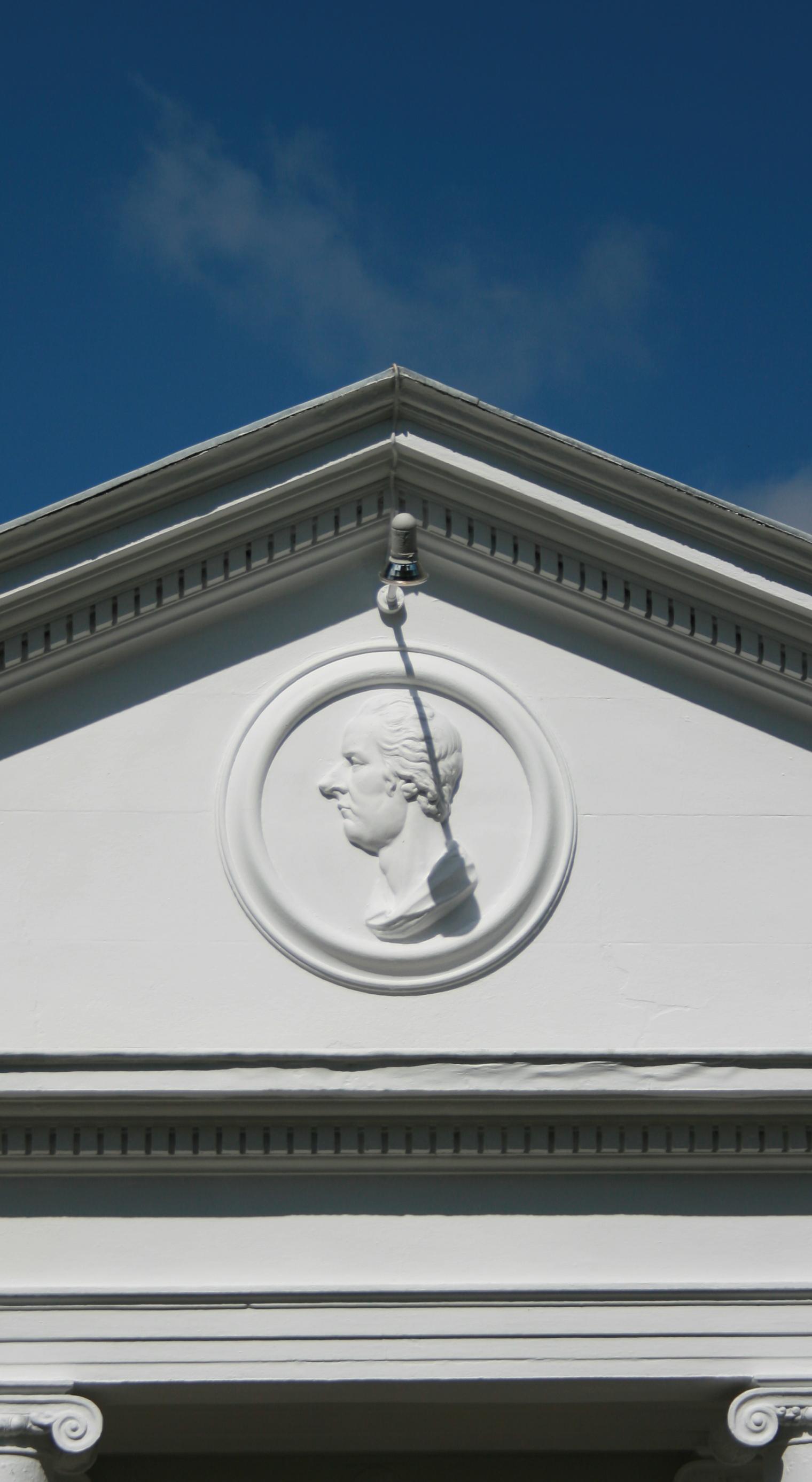 The Pitt Club buildings on
Jesus Lane with the relief profile of Pitt (large nose !) above the door
are now occupied by Pizza Express. Surprisingly enough they started out
as a swimming baths (the Roman Bath Co.), before being taken over by the
Pitt Club as its clubhouse. The Pitt Club is an organisation of
undergraduates from the older public schools. The University likes to
distance itself from the Club nowadays as it doesn't represent the sort
of modern image that the University wishes to present, and it has no
official standing. It does have a large number of distinguished former
and honorary members, all as you might expect to the right of the
political spectrum. A former catering manager of the
club, Marshall, did
rather well for himself in the motor trade.
The Pitt Club buildings on
Jesus Lane with the relief profile of Pitt (large nose !) above the door
are now occupied by Pizza Express. Surprisingly enough they started out
as a swimming baths (the Roman Bath Co.), before being taken over by the
Pitt Club as its clubhouse. The Pitt Club is an organisation of
undergraduates from the older public schools. The University likes to
distance itself from the Club nowadays as it doesn't represent the sort
of modern image that the University wishes to present, and it has no
official standing. It does have a large number of distinguished former
and honorary members, all as you might expect to the right of the
political spectrum. A former catering manager of the
club, Marshall, did
rather well for himself in the motor trade.
Pound Hill and Honey Hill
Pound Hill was an area where stray animals were kept, obviously enough. Honey
Hill, on the other hand is a local joke on the fact that the area was particularly
muddy. Local residents appear to have chosen to call it Pooh Corner instead.
Neither of these are actual hills of course.
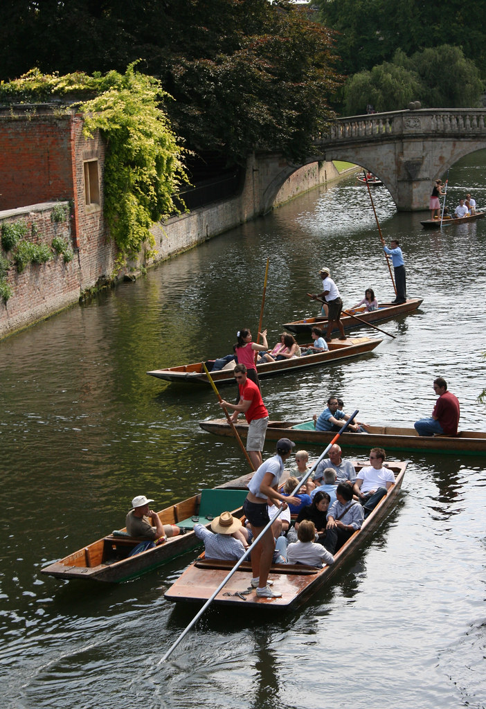 The bit of the river that goes
down the Backs used to have buildings or College Gardens down either
side. This made it hard for boats pulled by horses to navigate this
stretch down to the Mills at the mill pond just past Silver Street
Bridge as there was no tow-path. They got round this by putting a sunken
causeway down the middle of the river that the bargees could use to pole
their boats along. Horses also pulled barges by walking along this
causeway. The legacy is that there is a hard ridge right down the centre
of the river and deep mud to either side. Punting (for anyone who has
not seen it) involves propelling a shallow boat (called a "punt") by
means of a long pole that is poked into the river bed. The pole can also
be used to steer the punt, the trick being not to push it in so hard
that it gets stuck. The hard ridge in the river means that those that
know about it can move at some speed, while the soft mud means that
those that don't hardly make any progress at all. The latter group
includes nearly all of the tourists who try it, and the most
entertainment to be had from punting is sitting on the bank with a
bottle of something watching the tourists lose their poles and fall in.
It is possible to punt as far as Grantchester, or
slightly beyond (as
far as Byron's Pool), but few people have the stamina, or can afford the
punt rental. There are several chauffeur punt companies operating during
the summer, usually staffed by hard-up students. Interested tourists
should head for Magdalene or Silver Street Bridges where you will be
accosted by at least half-a-dozen young people with clipboards and
(often) straw boaters interested in your trade. These punt-pimps are
so numerous and sufficiently annoying if you walk through that area
frequently that I have seen locals wearing "No, I don't want to punt !" T-shirts.
The bit of the river that goes
down the Backs used to have buildings or College Gardens down either
side. This made it hard for boats pulled by horses to navigate this
stretch down to the Mills at the mill pond just past Silver Street
Bridge as there was no tow-path. They got round this by putting a sunken
causeway down the middle of the river that the bargees could use to pole
their boats along. Horses also pulled barges by walking along this
causeway. The legacy is that there is a hard ridge right down the centre
of the river and deep mud to either side. Punting (for anyone who has
not seen it) involves propelling a shallow boat (called a "punt") by
means of a long pole that is poked into the river bed. The pole can also
be used to steer the punt, the trick being not to push it in so hard
that it gets stuck. The hard ridge in the river means that those that
know about it can move at some speed, while the soft mud means that
those that don't hardly make any progress at all. The latter group
includes nearly all of the tourists who try it, and the most
entertainment to be had from punting is sitting on the bank with a
bottle of something watching the tourists lose their poles and fall in.
It is possible to punt as far as Grantchester, or
slightly beyond (as
far as Byron's Pool), but few people have the stamina, or can afford the
punt rental. There are several chauffeur punt companies operating during
the summer, usually staffed by hard-up students. Interested tourists
should head for Magdalene or Silver Street Bridges where you will be
accosted by at least half-a-dozen young people with clipboards and
(often) straw boaters interested in your trade. These punt-pimps are
so numerous and sufficiently annoying if you walk through that area
frequently that I have seen locals wearing "No, I don't want to punt !" T-shirts.
The Railway Station is quite a long way from the city centre. The
University insisted that it be built this far from the centre to stop
its young gentlemen (they were all male then) from wandering off to the
disreputable young ladies of London. Considering that the City's
favoured site was Jesus Green, I think the University did the right
thing. Actually the City eventually agreed that the chosen location was
the most practical, so it's not all the University's fault, and it did a
great deal to encourage urban development in
the Mill Road/Hills Road
areas. It's not that far really, but students have a distorted view of
geography. The University retained the right to search the station for
undergraduates, and had an Act of Parliament passed so that they could
require the railway companies to ban students from travelling, even
with a valid ticket (although it is believed that this right was never
exercised). They also would not allow trains to run to or from the station
on a Sunday, a ban which was not lifted until 1908. The station building is
quite pleasing, especially after recent renovation. Less pleasing is the
piped music they insist on playing, which is sometimes pleasant, but
often banal. The station also often smells interesting because of the
large Rank-Hovis mill/research centre next door. At the end of the
station car park is the Carter Bridge, a cycle bridge across the tracks which is intended
to lead cyclists away from the hideously dangerous Mill Road and its
bridge. It's the largest single span bridge of its kind in Britain, or
Europe, or the Universe, or something. It's also a bugger to cycle onto
from the west end because of the road layout, but is generally a good
thing, and great fun to free-wheel down.
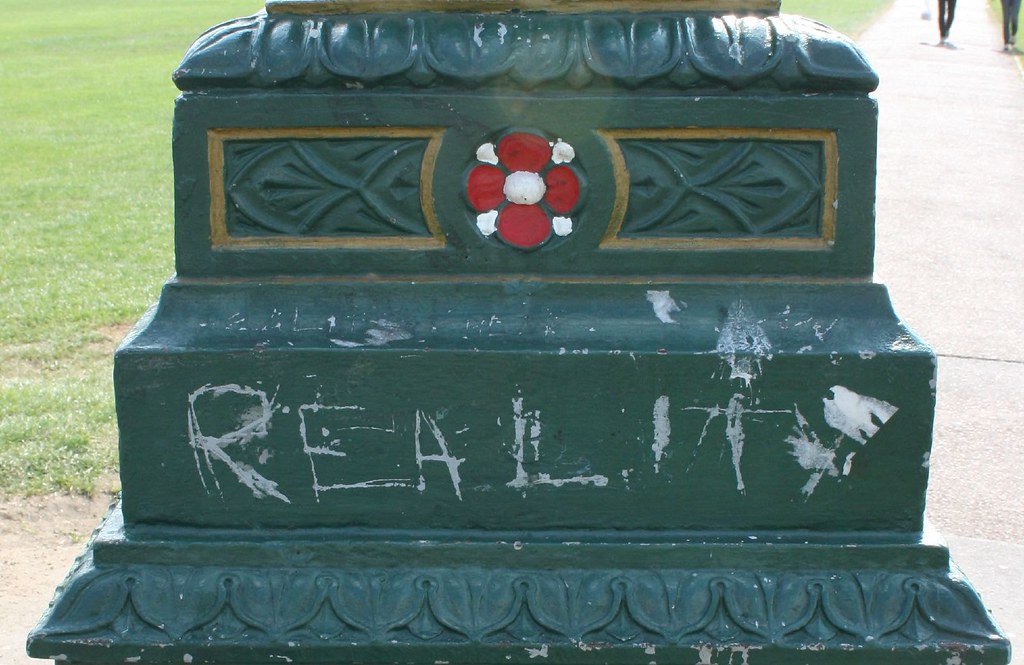 In the
middle of Parker's Piece is an old-fashioned lamppost. It has "Reality
Checkpoint" painted on the side, and has done since the early seventies,
apparently. If ever the words are painted out they reappear again
overnight, which just goes to show that there are some truly sad people
out there. What does it mean ? Who cares ? I believe the intention is to
inform students that from here onwards they can expect to meet a higher
proportion of "real" people and to moderate their behaviour
accordingly. There are, however, several pubs closer to the town centre
than this where talking loudly about your boat's placing in the bumps or
your essay crisis is likely to meet with a frosty reception, at best.
It is true that cycling across the Piece on a foggy night is a truly
eerie experience as the lamppost looms out at you, like a large looming
... lamppost. Stop Press: I passed this recently and couldn't see the
words - have they gone ? Anyone know ? Anyone care ? (Yes ! Thankyou C.Dawes who says "With reference to your
article, the words Reality Checkpoint have again reappeared in their rightful place, apparently written by two different
people as one is in large font, and the other really tiny, the tiny one
being, of course 'checkpoint'. Thought this'd help." May 2005). As of Sept. 2007, the word "Reality" appears on all 4 sides of the lamppost, but it is scratched or scrawled, not properly written.
In the
middle of Parker's Piece is an old-fashioned lamppost. It has "Reality
Checkpoint" painted on the side, and has done since the early seventies,
apparently. If ever the words are painted out they reappear again
overnight, which just goes to show that there are some truly sad people
out there. What does it mean ? Who cares ? I believe the intention is to
inform students that from here onwards they can expect to meet a higher
proportion of "real" people and to moderate their behaviour
accordingly. There are, however, several pubs closer to the town centre
than this where talking loudly about your boat's placing in the bumps or
your essay crisis is likely to meet with a frosty reception, at best.
It is true that cycling across the Piece on a foggy night is a truly
eerie experience as the lamppost looms out at you, like a large looming
... lamppost. Stop Press: I passed this recently and couldn't see the
words - have they gone ? Anyone know ? Anyone care ? (Yes ! Thankyou C.Dawes who says "With reference to your
article, the words Reality Checkpoint have again reappeared in their rightful place, apparently written by two different
people as one is in large font, and the other really tiny, the tiny one
being, of course 'checkpoint'. Thought this'd help." May 2005). As of Sept. 2007, the word "Reality" appears on all 4 sides of the lamppost, but it is scratched or scrawled, not properly written.
North of Cambridge this
dribbles into the Great Ouse, and South it merges with the Granta, an
old name for the whole thing. The bit that cuts through town like an
upside-down "L" comes in two parts, the upper and lower Cam. The upper
Cam ends at the Mill pond, and the lower Cam goes past the backs of some
of the colleges. People punt on the upper Cam and on the lower Cam to
the West of Jesus Lock, and people row on the deeper stretch to the
East. The Eastern lower Cam also supports a considerable population of
house boats in various states of repair, a description which also
matches their occupants. Some of them are neat and lovely, and some of
them you wonder how they stay afloat - and the same goes for the
boats... The river used to be navigable from the sea by
barges as far as the Mill Pond, and river freight was the major source
of income for the town (other than servicing the University) until the
coming of the railways. The original course of the river past the
medieval town was slightly to the West, but it was moved into a deeper
channel on the East side of its flood plain in an attempt to dry out
sufficient land for building. The area to the West of the river became
the Backs, the original river course still clearly visible as
ditches. Recent extensive and expensive flood prevention
schemes have attempted to put a stop to the major floods, but parts of Riverside and
Grantchester flooded in early 2001 and again in late 2001, along with much
of the rest of East Anglia. Increased rainfall in this part of the world is
said to be a predictable portent of global warming, and we had better
just get used to it and evolve webbed feet (or perhaps re-evolve webbed
feet - there is some evidence that inhabitants of the fenlands in prehistoric
times did indeed have webbed feet !). It doesn't help that this has always been a damp
place - most of East Anglia is just a little soil mixed into a lot of water.
Older houses in some areas near the river, for example on the river bank
opposite Fen Ditton, are raised off groundlevel with steps up to the
front door - they knew how to live with the river. Falling in the Cam is said to
result in a flu-like complaint called Cam Fever. This is presumed
to be due to the pollution, but is in most cases nowadays probably just
a hangover. Gwen Raverat, in her biography, relates the story that when
Queen Victoria visited the City she asked the Master of Trinity why
there was so much paper floating in the Cam - he replied that they were
notices telling people not to bathe in the river, which in effect they
were - it was actually paper that had been used for wiping bottoms. The
situation has since improved, but even recently the notorious shortage
of toilets in St.John's College caused many inhabitants of rooms
overlooking the river to relieve themselves from their windows -
sensible punters tried to get past St.John's as fast as they
could. Having college privies dumped on them was a common complaint of
the bargees when the river was used for trade. There used to be a
University Society called The Dampers for which the single
qualification for membership was unintentionally falling in the river.
David's Bookshop (David correctly pronounced with a French
accent, Dav-eed, like the artist, as the founder was Gustave David, a
Frenchman who first started with a market stall in 1896) used to be
where The Haunted Bookshop is now. It then moved into the current
shop, and a second shop that has now been taken over by part of the
Arts Theatre. There was until the Art's Theatre renovation a
small vegetarian restaurant here by the name of Nettles. It was tiny,
with room to seat about 8 people, but did very good business and the
best Apple Crumble ever made, sadly missed. The Haunted Bookshop is
reputed to have a ghost in residence upstairs, hence the name.
When I was an undergraduate I
travelled around Europe, as many students have done before and
since. Due to a combination of incompetence, alcohol, and an inability
to tell the difference between "East" and "West" in German, I found
myself at 3 in the morning on a train about to cross from Austria into
Czechoslovakia (then still communist, one country, and notorious at
least in James Bond films as containing the major training centres for
the KGB). The large and hostile border guard asked my profession, and on
being told I was an undergraduate at Cambridge nodded wisely and said
"Ah Cambridge". The 18 year-old soldiers with him, each about 7 feet
tall and carrying machine guns, also nodded and said "Ah
Cambridge". They clearly didn't speak another word of English. After
that point they all became very friendly, and let me through despite the
fact that I didn't have enough money for a visa. At the time I found
this vaguely worrying. The fact that all the famous post-war spies were
Cambridge men is not so surprising when you consider that the entire
"intelligence" community and the bulk of the House of Commons and Civil
Service were traditionally derived from either Oxford or Cambridge. From
Peter Wright's Spycatcher it is clear that there was an
equivalent but less notorious Oxford ring to the Philby, Burgess,
Maclean, Blunt group. The major recruitment centres were apparently the
Joint Services Language School Russian class, and a student society
called the Apostles, which had (and has since had) numerous
distinguished members, not all of them Communist homosexuals. Spying has
a long history here - the Elizabethan playwright (the one who's not
Shakespeare), Christopher Marlowe, was employed as a spy while still an
undergraduate at Corpus. He was sent to France to spy on the invasion
plans of exiled Catholics, and posed as a converted Catholic. This
caused him no end of problems when he returned to Cambridge, and the
University had to be officially instructed by the court that he wasn't
really Catholic, as otherwise they were not allowed to award him a
degree.
Hobson
founded the Spinning House as a workhouse, that is a place where the
poor were housed and given simple work - usually spinning in this
case. The Spinning House also had a small prison for vagrants who
refused to work. This use came to predominate, and later the House was
used just as a prison for "fallen" women. The University preserved the
right to arrest such women right until the end of the 19th Century when
there was a notorious case of mistaken identity and two "respectable"
women were arrested instead. They were, they claimed, innocent
seamstresses out for a country jaunt with a wagon load of
undergraduates. It's true that the youngest of the two sisters was only
14, but that was not an uncommon age for prostitutes then. The scandal
eventually bought about the end to many of the University's ancient
rights and privileges over the townsfolk. The Spinning House was
situated on Regent's Street, demolished in 1901, the site was occupied
by the Police Station (you can still see "Police Station" clearly
inscribed over the door, probably confusing for visitors) and the
building is now council offices.
Nobody is
too sure when the Sturbridge Fair started, possibly over a thousand
years ago. It was given a royal charter in 1211 as a means of raising
funds for the Leper Hospital. At its height in medieval times it
lasted for weeks and was the largest fair in Europe, stretching from the
current Stourbridge Common along the river as far as the current
Midsummer Common - an area much larger than
Cambridge itself, at the time. Traders came from all
over Europe, even as far afield
as Venice. Bunyan's Vanity Fair is based on this event. Street names
surrounding Stourbridge Common today indicate the produce that was sold
in that particular area, such as Oyster Row, Garlic Row and Cheddars
Lane. A large area of the fair was given over to what Neil Stephenson, in his
fictionalised account of the fair in Quicksilver, calls "speciality
prostitutes". Unfortunately the modern street names do not preserve echoes of
that particular trade. The fair was discontinued in 1934 due to lack of interest, the
Mayor at the time reported that she opened the proceedings to an
audience of two women, while the only stall was a Stop-me-and-buy-one
ice cream vendor. The modern Strawberry Fair is a significantly scaled
down modern revival. The name Stourbridge probably derives from
steer-bridge, ie a bridge for oxen - probably something to do with
toll money collected for oxen crossing the Magdalene Street bridge as
the bridge to the common is recent (and isn't wide enough for oxen !).
A faint memory
of Sturbridge Fair, and enormously
popular with almost everyone who
doesn't have to live near it. Held
on Midsummer Common on a Saturday in
June, it features stalls selling everything from silly hats to
rizlas. There are a vast number of food stalls, beer tents, play areas
for children and several stages for live bands. A good time is generally
had by all (unless it rains), and a lot of beer and "non-tobacco cigarettes"
are consumed. For the latter reason, and because it attracts petty
thieves, it's not particularly popular with the Police. The event also
attracts "travellers" from far and wide, who seem to think they have a
right to occupy the surrounding streets for the following week. On the
whole people are well behaved, but there have been disturbances. As the
occupants of the Brunswick Walk area are generally retired and
respectable, it's not surprising they take exception to travellers
urinating in their gardens. However, if the sun shines it can be a
highlight of the entire year (I mean the fair, not the urinating
crusties !). A lot of tourists come here,
but few are found more than a few hundred yards
from King's Parade. The
same could be said about the students. The Tourist Office is housed in
the old town Library (the words "Free Library" can still be seen over
the door), behind the Guildhall, and is very attractive inside. More
than 3 million tourists a year visit Cambridge, King's Chapel being one
of the biggest tourist attractions in Britain. But as the City's
permanent population is only 100,000 (about 92,000 at the 1991 census,
not counting students) it's not surprising we tend to feel a little
overwhelmed in the summer. Two thirds of the tourists come just for the
day.
A lot of tourists come here,
but few are found more than a few hundred yards
from King's Parade. The
same could be said about the students. The Tourist Office is housed in
the old town Library (the words "Free Library" can still be seen over
the door), behind the Guildhall, and is very attractive inside. More
than 3 million tourists a year visit Cambridge, King's Chapel being one
of the biggest tourist attractions in Britain. But as the City's
permanent population is only 100,000 (about 92,000 at the 1991 census,
not counting students) it's not surprising we tend to feel a little
overwhelmed in the summer. Two thirds of the tourists come just for the
day.
Town and Gown
Most modern
residents would probably think of the pub on Northampton Street by
this name when confronted with this phrase (or they would have done
before it changed its name !). In fact the history of the
City is one long story of conflict between the two factions, both at the
low level of street violence up to the official level, for example the
University's insistence on the siting of the Railway Station. Stories
of violence occur again and again, often resulting in deaths, and often
resulting in the townsfolk being imprisoned or worse while the students
got off comparatively lightly. In the Civil War the University was
staunchly Royalist while the town was equally staunchly
Commonwealth. Cromwell was an alumni of Sidney Sussex College and one of
the town's Members of Parliament (elected 1640). He occupied the town
and largely succeeded in an attempt to stop the University sending
financial aid to the King. He also blew up most of the town's bridges,
many of which were not rebuilt for a considerable period.
The University could place a shopkeeper
off-limits to students, effectively depriving them of trade, a practice
known as discommoning. The rights of the University over the townsfolk
extended up to the end of the 19th Century, when there was a notorious
case of wrongful arrest. Today the University and City try to get along,
and the University is consulted in planning decisions that affect it as
it is the major employer - it is doubtful if it could influence a major
decision such as the site of a Railway Station today, but it did have a
major influence on, for example, the commercial development
of Lion
Yard. Undergraduates no longer have to wear a gown when out of college
and are for the most part indistinguishable from young townsfolk, and
the Proctors no longer patrol the streets looking for miscreants. The
main complaint of townsfolk today is that most of the retail property is
owned by one or other of the colleges, and the rents are in some areas
very high - hardly a cause likely to incite a riot.
Cambridge didn't have trams for
long, and never had motor or electric trams - they were all horse drawn.
From the Tram depot (now a pub) on East Road the trams went past
Parker's Piece,
along Lensfield Road and along Trumpington Street to
Senate House Hill, and there was another route from the railway station
along Hills Road and Regents Street. There is occasionally talk of
introducing trams as an environmentally-friendly mode of public
transport to counter Cambridge's notorious traffic problems.
The University was a major centre during the
Reformation, and so not surprisingly many of its more prominent members
had a difficult time while the Tudor monarchs tried to make up their
minds as to which was the true path to peace, love and understanding.
Queen Mary in particular didn't have a happy relationship with
Cambridge, and it's not surprising she earned the nickname "Bloody
Mary". Two prominent deceased Protestant theologians earned her
displeasure, Martin Bucer and Paul Fagius. Their coffins were removed
from their resting places (St.Martin's
and Great St.Mary's) and
ceremonially burned on Market
Hill. What little remained of their remains were later just as
ceremoniously reburied on the accession of Elizabeth I. Mary also had
the protestant John Hullier burned on Jesus Green. Townsfolk are
reported to have stripped the body of remaining identifiable parts
afterwards to provide relics. Other prominent local Protestants (many
associated with St.Edward's Church) met similar ends elsewhere: Hugh
Latimer and Cranmer in Oxford, Robert Barnes at Smithfield, and
Thomas Bilney in Norwich. Religion wasn't the only subject that could
get you into trouble at this time - several women were hanged on Jesus
Green for alleged witchcraft in the reign of Elizabeth I, one of them
for owning a frog (thought to be her familiar). What happened to the
frog is not recorded.
The
University used to be keen on denying distracting pleasures to its
younger members, hence the opposition to the site of
the Railway
Station, and the strict rules against going to the Newmarket races,
theatrical performances, and cricket matches. Many of the pleasures
nevertheless favoured by undergraduates involved cruelty to dumb animals
(other than their Tutors). The town had at one time cock-fighting on
Market Hill and
bear-baiting and bull-fighting
on Peas Hill. There were
also bear pits at Chesterton. The walled garden next
to Midsummer House
was home of Callaby's famous menagerie, and the words "Callaby Dog
Fancier" could be seen there until relatively recently. You could chose
from rat fighting - put a terrier in a pen with some rats and bet on how
long it takes to kill them, or pigeon-shooting, the pigeon being tied by
one leg to a stake. An urban equivalent to fox hunting, cat hunting,
undertaken on foot, would be particularly frowned on by the cat friendly
Cantabridgians of today (myself included). An undergraduate society, the
Trinity Foot Beagles, still practise hunting on foot although not for
cats. They are, not surprisingly, consistently the brunt of criticism
and demonstrations by animal rights activists.
A practice peculiar to
Cambridge now sadly discontinued. Tradesmen selling butter would divide
it into blocks weighing 1 pound and then roll it out into a long
cylinder between two flat boards each 3 feet long (or 1 yard, hence the
name). They would then carry these cylinders around to peoples houses
and sell it by length - so for example if you just wanted a quarter
pound then he would give you a 9 inch length. Refrigeration wasn't
common, so people tended to buy small quantities more frequently than
they do now. This system had the advantage that the tradesman didn't
have to carry around a range of weights, just a ruler. The University had jurisdiction
over the weights and measures used in the town, enforced by the
Proctors. One of the Proctors' symbols of office is still a butter
measure - a brass rod of the same dimensions as one of these yard-long
butter cylinders that could be compared to a given length of butter to
check that the tradesman wasn't cheating his customers. The practice
died out with the introduction of rationing in the First World War.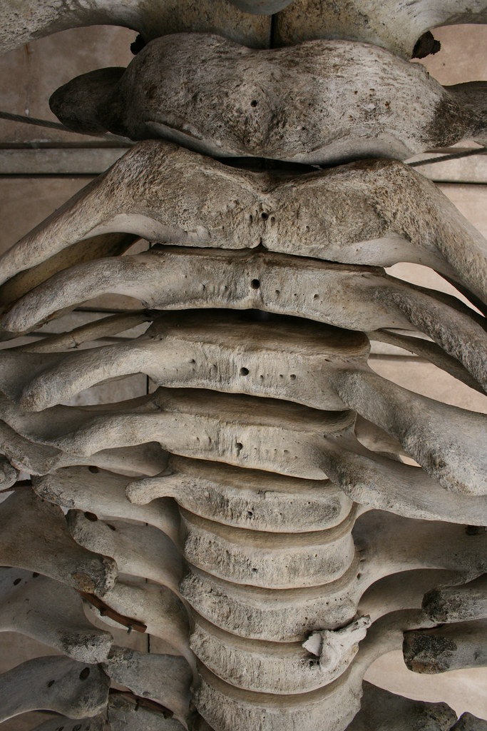
The definitive source is "Cambridge Street Names by Gray and
Stubbings (CUP 2000). This is a small selection:
Sources
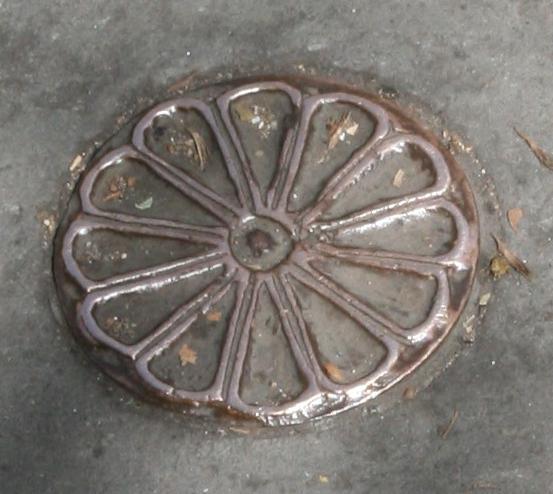 brass Marguerites
 Fosters', now Lloyds, Bank
 Kapitza's Crocodile