Using real-time road traffic data to evaluate congestion
The TIME-EACM project has shown that by using existing sources of information about traffic flow it is possible to create a minute-by-minute image of congestion in cities.
Britain’s roads are becoming increasingly congested. Motorways and major roads have sensors and information displays but it is too expensive to fully monitor cities. Researchers at Cambridge University’s Computer Laboratory, aim to decrease the congestion in cities by developing ways for low-cost monitoring methods to analyse the flow of traffic.
The TIME project (Transport Information Monitoring Environment) aims to inform businesses, government, and the public so that they may use the roads with less frustration; help transport operators respond to changes while providing a good service; and allow road planning and public policy to be informed by quantitative evidence. Focusing on the city of Cambridge, the TIME project has ‘re-purposed’ data sources from Cambridge County Council and Stagecoach, incorporating them into a system that can transport, collect, and analyse data. No extra expense is incurred for information gathering because the infrastructure required to collect the data is already in operation.
To predict which roads are likely to be most congested at which times, researchers collected bus position data because the movement of buses gives a good idea of the traffic conditions in general. The bus data were combined with data from a number of sources of information about the road network, including ‘crowd-sourced’ data from OpenStreetMap, showing bus lanes, traffic lights and bus stops.
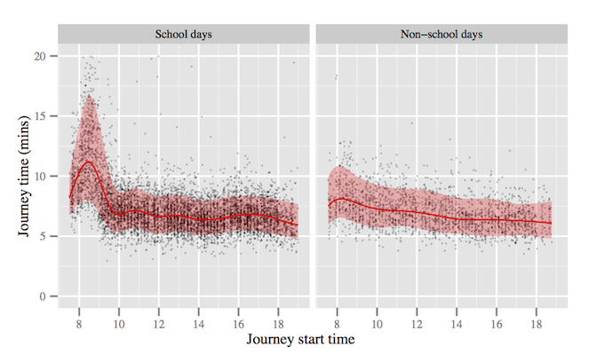
People suspect that traffic is worse during school terms but, until now, there was little hard evidence of this. Using bus positions already collected by Stagecoach and map data from OpenStreetMap, the team was able to demonstrate that bus journeys are longer, and that journey times vary more during term time. This can be seen here:
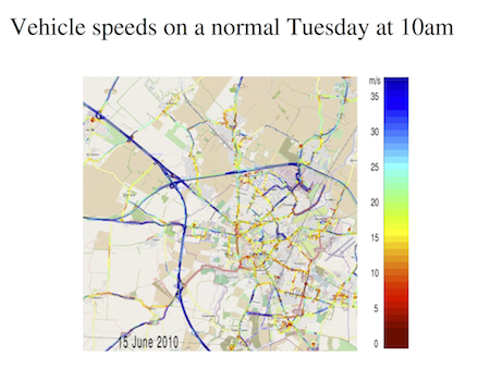
The team was also able to help traffic planners by illustrating the extent and duration of congestion that can be caused by a single incident, for example a lorry fire on the A14 Cambridge ring road. On Tuesday June 22nd 2010 such a fire occurred at 6am - the difference shown as follows:
 |
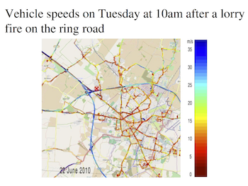 |
Dr David Evans, a researcher on the TIME project said: “The A14 is a major road for the region and when something goes wrong on it, the effects are felt throughout the city and outlying villages.”
TIME has investigated the use of low-cost, static, infra-red detectors to count traffic that pass in each direction. The detector was mounted on a lamp post on Madingley Road, and transmitted traffic counts to the Computer Laboratory.
By collecting real-time traffic-light data, from SCOOT (Split Cycle Offset Optimisation Technique), to count vehicles at some traffic-light-controlled junctions in Cambridge, the team has shown how to combine SCOOT and bus data to give buses priority at traffic lights. The SCOOT system comprises inductive loops in the roads approaching the junctions and schedules the lights to take account of the detected queue lengths.
By archiving these data and analysing them statistically, the TIME team can determine the effects of exceptional circumstances, such as scheduled work by utilities, accidents in the city, or closure of the surrounding trunk roads on vehicle speeds throughout the city. Dr Richard Gibbens said “Our approach has helped us both quantify the effects of congestion on urban road networks and visualise the consequences in a variety of formats”.
Congestion can be tackled either by increasing road network capacity or by decreasing demand in congested areas, especially during peak hours. The scope to increase capacity is limited, especially in urban environments. Demand must be reduced or displaced, by encouraging drivers to change mode of transport, alter the times of day or day of travel, or not to travel at all.
To decrease demand local governments can adopt a “carrot approach” (provision of information) or “stick approach” (road-user pricing) to managing the flow of traffic through a city. This implies installing Automatic Number Plate Recognition (ANPR) as in the Durham Road User Charge Zone or the London Congestion charge. ANPR potentially invades privacy.
Professor Jean Bacon said: “Providing citizens with accurate information on traffic conditions can encourage journeys at times of low congestion, and an uptake of public transport. Most cities have the types of data we have used in Cambridge and the approach could be used more extensively by Cambridge County Council and extended nationally. Also, crowd-sourced traffic data could be used to complement the data we have obtained from sensing systems already in place.”